|
|
|||||||||||||||||
| Point ID: 5083 | Downloads | Plots | Site Data | Code: 03AC002 |
|
|
|||||||||||||||||
| Download | |
|---|---|
| Site Descriptor Information | Site Time Series Data |
| Link to all available data | |
| View: | Time Series | All |
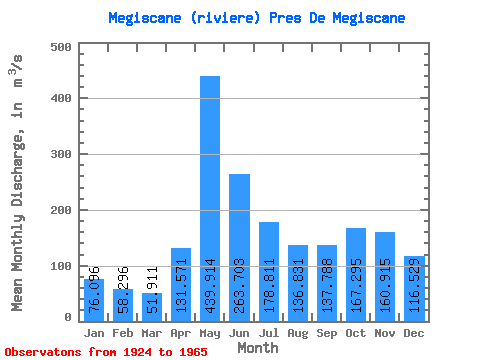
| Units: | mm |
| Statistic | Jan | Feb | Mar | Apr | May | Jun | Jul | Aug | Sep | Oct | Nov | Dec | Annual |
|---|---|---|---|---|---|---|---|---|---|---|---|---|---|
| Mean | 76.10 | 58.30 | 51.91 | 131.57 | 439.91 | 263.70 | 178.81 | 136.83 | 137.79 | 167.29 | 160.91 | 116.53 | 167.06 |
| Standard Deviation | 17.03 | 12.90 | 11.46 | 56.66 | 138.31 | 103.29 | 74.51 | 63.04 | 64.43 | 85.53 | 59.88 | 27.37 | 32.09 |
| Min | 38.80 | 32.80 | 31.80 | 45.50 | 216.00 | 116.00 | 73.80 | 43.90 | 50.20 | 62.80 | 58.50 | 52.90 | 111.98 |
| Max | 117.00 | 82.90 | 81.80 | 298.00 | 801.00 | 476.00 | 366.00 | 266.00 | 311.00 | 542.00 | 290.00 | 173.00 | 248.88 |
| Coefficient of Variation | 0.22 | 0.22 | 0.22 | 0.43 | 0.31 | 0.39 | 0.42 | 0.46 | 0.47 | 0.51 | 0.37 | 0.23 | 0.19 |
 Return to R-Arctic Net Home Page