|
|
|||||||||||||||||
| Point ID: 5083 | Downloads | Plots | Site Data | Code: 03AC002 |
|
|
|||||||||||||||||
| Download | |
|---|---|
| Site Descriptor Information | Site Time Series Data |
| Link to all available data | |
|
|
| View: | Statistics | Time Series |
| Units: | m3/s |
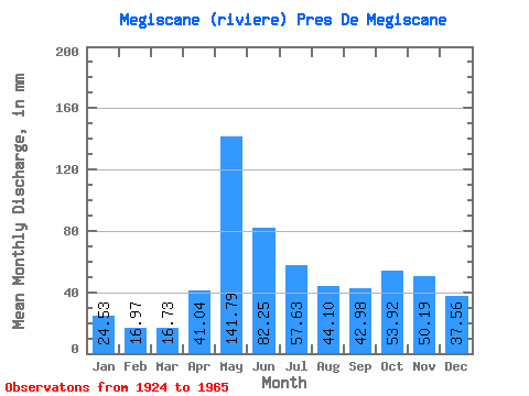
| Statistic | Jan | Feb | Mar | Apr | May | Jun | Jul | Aug | Sep | Oct | Nov | Dec | Annual |
|---|---|---|---|---|---|---|---|---|---|---|---|---|---|
| Mean | 24.52 | 17.12 | 16.73 | 41.04 | 141.77 | 82.25 | 57.62 | 44.09 | 42.98 | 53.91 | 50.19 | 37.55 | 634.46 |
| Standard Deviation | 5.49 | 3.79 | 3.69 | 17.67 | 44.57 | 32.22 | 24.01 | 20.32 | 20.10 | 27.56 | 18.68 | 8.82 | 121.86 |
| Min | 12.50 | 9.63 | 10.25 | 14.19 | 69.61 | 36.18 | 23.78 | 14.15 | 15.66 | 20.24 | 18.25 | 17.05 | 425.29 |
| Max | 37.70 | 24.34 | 26.36 | 92.95 | 258.13 | 148.47 | 117.95 | 85.72 | 97.00 | 174.67 | 90.45 | 55.75 | 945.19 |
| Coefficient of Variation | 0.22 | 0.22 | 0.22 | 0.43 | 0.31 | 0.39 | 0.42 | 0.46 | 0.47 | 0.51 | 0.37 | 0.23 | 0.19 |
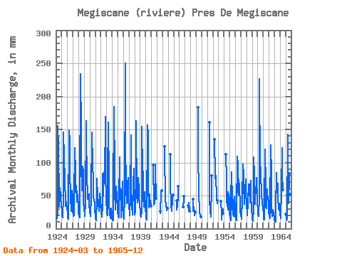
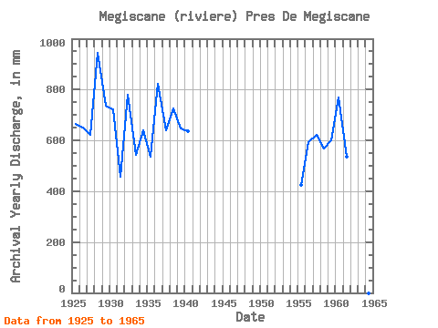
| Year | Jan | Feb | Mar | Apr | May | Jun | Jul | Aug | Sep | Oct | Nov | Dec | Annual | 1924 | 16.34 | 24.11 | 160.81 | 121.33 | 47.37 | 33.52 | 61.45 | 51.24 | 42.11 | 40.60 | 1925 | 23.23 | 17.41 | 17.05 | 50.53 | 150.50 | 107.92 | 76.05 | 81.53 | 33.69 | 41.57 | 36.49 | 33.84 | 666.93 | 1926 | 23.49 | 16.15 | 15.08 | 14.19 | 154.36 | 131.94 | 89.27 | 50.27 | 26.64 | 27.46 | 58.02 | 48.02 | 652.22 | 1927 | 28.62 | 18.18 | 21.01 | 42.42 | 125.68 | 82.97 | 57.69 | 67.03 | 40.86 | 58.33 | 46.79 | 34.80 | 621.86 | 1928 | 25.52 | 17.68 | 17.11 | 48.35 | 241.70 | 148.47 | 101.83 | 58.97 | 63.63 | 97.32 | 86.09 | 42.54 | 945.19 | 1929 | 30.10 | 21.11 | 18.98 | 40.55 | 168.22 | 133.81 | 88.62 | 46.08 | 50.84 | 49.95 | 52.09 | 37.70 | 735.89 | 1930 | 25.72 | 18.06 | 19.14 | 49.59 | 150.17 | 127.57 | 117.95 | 56.40 | 46.79 | 44.47 | 38.68 | 30.07 | 721.90 | 1931 | 18.47 | 13.27 | 12.57 | 44.29 | 78.31 | 48.03 | 40.60 | 41.25 | 26.36 | 37.06 | 53.34 | 43.83 | 456.06 | 1932 | 30.97 | 24.34 | 18.30 | 36.49 | 85.72 | 48.97 | 88.62 | 73.80 | 74.55 | 174.67 | 87.34 | 41.25 | 781.34 | 1933 | 29.16 | 21.99 | 20.43 | 83.91 | 165.64 | 72.36 | 38.67 | 24.01 | 15.66 | 20.24 | 30.79 | 22.69 | 544.48 | 1934 | 16.21 | 11.45 | 12.60 | 43.04 | 190.46 | 82.66 | 58.33 | 29.81 | 47.72 | 66.39 | 46.48 | 39.64 | 641.49 | 1935 | 25.88 | 17.85 | 17.14 | 41.80 | 111.18 | 64.57 | 58.97 | 28.59 | 17.12 | 48.02 | 71.12 | 36.42 | 537.04 | 1936 | 19.75 | 13.33 | 21.56 | 42.73 | 258.13 | 139.11 | 52.53 | 49.95 | 37.74 | 71.54 | 76.73 | 45.76 | 824.95 | 1937 | 33.52 | 22.32 | 20.62 | 48.97 | 145.99 | 64.25 | 34.48 | 21.95 | 32.44 | 69.61 | 90.45 | 55.75 | 638.70 | 1938 | 30.07 | 20.11 | 26.36 | 92.95 | 168.54 | 50.53 | 40.60 | 77.67 | 76.42 | 59.62 | 50.22 | 34.48 | 725.26 | 1939 | 28.00 | 21.32 | 18.30 | 27.04 | 159.52 | 87.02 | 89.91 | 48.98 | 33.06 | 51.88 | 54.90 | 31.97 | 648.86 | 1940 | 21.82 | 15.59 | 14.05 | 19.40 | 161.13 | 142.23 | 66.06 | 32.87 | 52.09 | 36.74 | 42.42 | 34.48 | 637.28 | 1941 | 99.58 | 36.18 | 47.70 | 39.96 | 97.00 | 91.20 | 45.85 | 1942 | 27.04 | 23.43 | 58.01 | 57.39 | 1943 | 128.58 | 111.98 | 48.34 | 34.16 | 38.05 | 28.30 | 30.63 | 1944 | 116.01 | 73.61 | 33.19 | 30.16 | 25.86 | 46.08 | 50.84 | 1945 | 43.83 | 29.36 | 35.25 | 49.95 | 63.94 | 1946 | 32.44 | 44.79 | 48.97 | 1947 | 35.77 | 26.70 | 40.93 | 25.83 | 1948 | 44.92 | 27.43 | 34.16 | 22.64 | 20.95 | 24.92 | 1949 | 189.81 | 109.17 | 60.59 | 24.27 | 23.70 | 21.37 | 18.25 | 1951 | 166.61 | 43.04 | 28.71 | 18.14 | 19.25 | 64.45 | 80.16 | 1952 | 139.22 | 80.47 | 71.54 | 82.50 | 46.16 | 39.32 | 42.73 | 1953 | 41.17 | 23.78 | 14.15 | 26.67 | 30.32 | 22.99 | 1954 | 116.01 | 74.86 | 40.60 | 39.32 | 28.82 | 57.69 | 49.91 | 47.70 | 1955 | 25.33 | 15.30 | 13.18 | 46.16 | 87.98 | 42.11 | 33.84 | 22.69 | 18.34 | 40.60 | 48.35 | 32.55 | 425.29 | 1956 | 21.30 | 13.01 | 12.76 | 25.36 | 112.47 | 96.69 | 59.30 | 51.88 | 75.17 | 64.13 | 37.12 | 27.71 | 595.09 | 1957 | 20.79 | 15.41 | 14.89 | 44.92 | 100.55 | 53.02 | 91.20 | 38.35 | 56.14 | 60.59 | 74.55 | 55.75 | 623.86 | 1958 | 37.70 | 22.93 | 20.75 | 39.92 | 69.61 | 61.76 | 60.91 | 40.93 | 61.45 | 74.44 | 48.66 | 30.61 | 568.57 | 1959 | 18.85 | 13.01 | 12.21 | 31.50 | 111.18 | 80.79 | 38.35 | 43.51 | 62.07 | 67.67 | 77.04 | 45.12 | 599.96 | 1960 | 24.56 | 19.97 | 19.34 | 49.59 | 233.32 | 84.84 | 96.36 | 83.14 | 53.96 | 37.38 | 37.43 | 34.48 | 769.76 | 1961 | 20.53 | 13.45 | 13.41 | 31.50 | 123.43 | 65.19 | 35.45 | 31.68 | 59.26 | 55.11 | 46.16 | 41.25 | 534.67 | 1962 | 25.55 | 18.47 | 16.34 | 27.01 | 130.52 | 80.79 | 29.26 | 19.92 | 24.30 | 29.68 | 21.77 | 17.05 | 439.54 | 1963 | 12.50 | 9.63 | 10.25 | 29.45 | 87.01 | 53.96 | 71.54 | 70.25 | 47.10 | 30.13 | 37.74 | 32.55 | 489.70 | 1964 | 21.14 | 16.15 | 15.79 | 58.95 | 126.33 | 80.47 | 60.59 | 1965 | 23.33 | 14.68 | 12.83 | 14.35 | 147.60 | 74.55 | 39.64 | 85.72 | 78.29 | 97.32 | 52.40 | 32.87 | 670.06 |
|---|
 Return to R-Arctic Net Home Page