|
|
|||||||||||||||||
| Point ID: 464 | Downloads | Plots | Site Data | Code: 05DC007 |
|
|
|||||||||||||||||
| Download | |
|---|---|
| Site Descriptor Information | Site Time Series Data |
| Link to all available data | |
| View: | Time Series | All |
| Units: | m3/s |
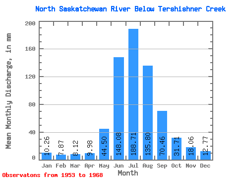
| Statistic | Jan | Feb | Mar | Apr | May | Jun | Jul | Aug | Sep | Oct | Nov | Dec | Annual |
|---|---|---|---|---|---|---|---|---|---|---|---|---|---|
| Mean | 10.26 | 7.94 | 8.12 | 9.98 | 44.49 | 148.08 | 188.68 | 135.78 | 70.46 | 31.70 | 18.06 | 12.77 | 701.18 |
| Standard Deviation | 2.73 | 0.93 | 0.68 | 1.76 | 17.48 | 30.58 | 19.74 | 25.20 | 18.27 | 6.67 | 3.16 | ||
| Min | 8.33 | 7.28 | 7.64 | 7.80 | 23.75 | 97.28 | 158.34 | 98.45 | 49.84 | 21.27 | 18.06 | 10.53 | 701.18 |
| Max | 12.19 | 8.59 | 8.61 | 11.86 | 73.66 | 204.56 | 231.31 | 185.88 | 105.95 | 40.96 | 18.06 | 15.01 | 701.18 |
| Coefficient of Variation | 0.27 | 0.12 | 0.08 | 0.18 | 0.39 | 0.21 | 0.10 | 0.19 | 0.26 | 0.21 | 0.25 |
 Return to R-Arctic Net Home Page