|
|
|||||||||||||||||
| Point ID: 464 | Downloads | Plots | Site Data | Code: 05DC007 |
|
|
|||||||||||||||||
| Download | |
|---|---|
| Site Descriptor Information | Site Time Series Data |
| Link to all available data | |
| View: | Time Series | All |
| Units: | mm |
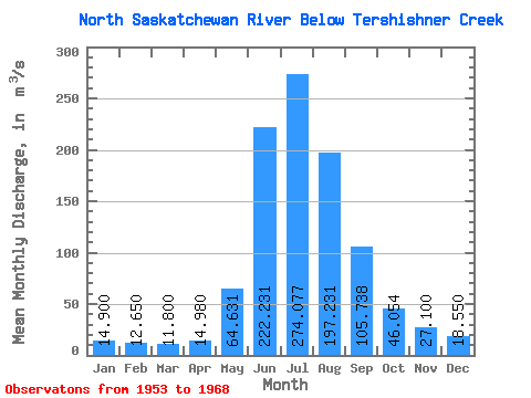
| Statistic | Jan | Feb | Mar | Apr | May | Jun | Jul | Aug | Sep | Oct | Nov | Dec | Annual |
|---|---|---|---|---|---|---|---|---|---|---|---|---|---|
| Mean | 14.90 | 12.65 | 11.80 | 14.98 | 64.63 | 222.23 | 274.08 | 197.23 | 105.74 | 46.05 | 27.10 | 18.55 | 86.42 |
| Standard Deviation | 3.96 | 1.48 | 0.99 | 2.65 | 25.40 | 45.90 | 28.67 | 36.60 | 27.43 | 9.69 | 4.60 | ||
| Min | 12.10 | 11.60 | 11.10 | 11.70 | 34.50 | 146.00 | 230.00 | 143.00 | 74.80 | 30.90 | 27.10 | 15.30 | 86.42 |
| Max | 17.70 | 13.70 | 12.50 | 17.80 | 107.00 | 307.00 | 336.00 | 270.00 | 159.00 | 59.50 | 27.10 | 21.80 | 86.42 |
| Coefficient of Variation | 0.27 | 0.12 | 0.08 | 0.18 | 0.39 | 0.21 | 0.10 | 0.19 | 0.26 | 0.21 | 0.25 |
 Return to R-Arctic Net Home Page