|
|
|||||||||||||||||
| Point ID: 464 | Downloads | Plots | Site Data | Code: 05DC007 |
|
|
|||||||||||||||||
| Download | |
|---|---|
| Site Descriptor Information | Site Time Series Data |
| Link to all available data | |
|
|
| View: | Statistics | Time Series |
| Units: | m3/s |
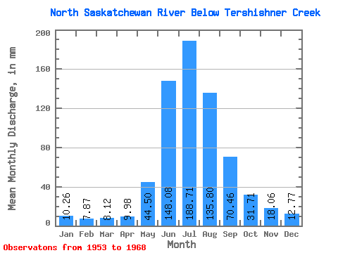
| Statistic | Jan | Feb | Mar | Apr | May | Jun | Jul | Aug | Sep | Oct | Nov | Dec | Annual |
|---|---|---|---|---|---|---|---|---|---|---|---|---|---|
| Mean | 10.26 | 7.94 | 8.12 | 9.98 | 44.49 | 148.08 | 188.68 | 135.78 | 70.46 | 31.70 | 18.06 | 12.77 | 701.18 |
| Standard Deviation | 2.73 | 0.93 | 0.68 | 1.76 | 17.48 | 30.58 | 19.74 | 25.20 | 18.27 | 6.67 | 3.16 | ||
| Min | 8.33 | 7.28 | 7.64 | 7.80 | 23.75 | 97.28 | 158.34 | 98.45 | 49.84 | 21.27 | 18.06 | 10.53 | 701.18 |
| Max | 12.19 | 8.59 | 8.61 | 11.86 | 73.66 | 204.56 | 231.31 | 185.88 | 105.95 | 40.96 | 18.06 | 15.01 | 701.18 |
| Coefficient of Variation | 0.27 | 0.12 | 0.08 | 0.18 | 0.39 | 0.21 | 0.10 | 0.19 | 0.26 | 0.21 | 0.25 |
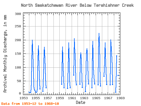
| Year | Jan | Feb | Mar | Apr | May | Jun | Jul | Aug | Sep | Oct | Nov | Dec | Annual | 1953 | 10.53 | 1954 | 8.33 | 7.28 | 7.64 | 7.80 | 43.37 | 125.94 | 206.53 | 149.39 | 85.29 | 30.77 | 18.06 | 15.01 | 701.18 | 1955 | 12.19 | 8.59 | 8.61 | 10.06 | 23.75 | 132.60 | 185.19 | 110.15 | 66.43 | 21.27 | 1956 | 11.86 | 73.66 | 155.25 | 178.99 | 135.62 | 58.70 | 25.82 | 1959 | 39.59 | 146.59 | 181.06 | 98.45 | 58.84 | 26.23 | 1960 | 23.96 | 97.28 | 196.20 | 118.41 | 53.71 | 26.16 | 1961 | 73.66 | 204.56 | 158.34 | 154.90 | 55.24 | 36.76 | 1962 | 39.72 | 124.60 | 158.34 | 132.18 | 61.84 | 27.26 | 1963 | 11.53 | 47.16 | 148.59 | 174.17 | 148.70 | 101.28 | 40.96 | 1964 | 26.30 | 167.25 | 201.71 | 102.58 | 62.90 | 40.48 | 1965 | 37.31 | 160.58 | 231.31 | 185.88 | 49.84 | 32.42 | 1966 | 69.53 | 119.94 | 196.20 | 152.14 | 85.29 | 38.76 | 1967 | 37.59 | 200.56 | 190.01 | 156.27 | 105.95 | 38.48 | 1968 | 8.66 | 42.82 | 141.26 | 194.83 | 120.48 | 70.63 | 26.78 |
|---|
 Return to R-Arctic Net Home Page