|
|
|||||||||||||||||
| Point ID: 459 | Downloads | Plots | Site Data | Code: 05DC002 |
|
|
|||||||||||||||||
| Download | |
|---|---|
| Site Descriptor Information | Site Time Series Data |
| Link to all available data | |
| View: | Time Series | All |
| Units: | m3/s |
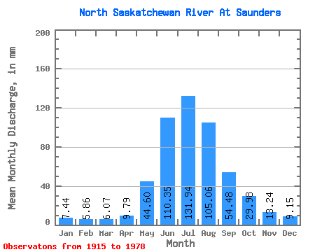
| Statistic | Jan | Feb | Mar | Apr | May | Jun | Jul | Aug | Sep | Oct | Nov | Dec | Annual |
|---|---|---|---|---|---|---|---|---|---|---|---|---|---|
| Mean | 7.43 | 5.91 | 6.07 | 9.79 | 44.59 | 110.34 | 131.92 | 105.05 | 54.48 | 29.97 | 13.24 | 9.15 | 600.71 |
| Standard Deviation | 1.31 | 1.08 | 1.04 | 2.21 | 15.54 | 38.90 | 48.17 | 39.70 | 13.37 | 9.23 | 3.00 | 2.71 | 57.47 |
| Min | 6.07 | 4.21 | 4.58 | 7.08 | 26.47 | 41.29 | 36.07 | 25.85 | 27.93 | 18.11 | 7.49 | 6.59 | 497.25 |
| Max | 10.33 | 7.61 | 7.84 | 12.86 | 95.50 | 170.79 | 223.17 | 189.43 | 85.39 | 52.42 | 17.98 | 13.86 | 653.98 |
| Coefficient of Variation | 0.18 | 0.18 | 0.17 | 0.23 | 0.35 | 0.35 | 0.36 | 0.38 | 0.24 | 0.31 | 0.23 | 0.30 | 0.10 |
 Return to R-Arctic Net Home Page