|
|
|||||||||||||||||
| Point ID: 459 | Downloads | Plots | Site Data | Code: 05DC002 |
|
|
|||||||||||||||||
| Download | |
|---|---|
| Site Descriptor Information | Site Time Series Data |
| Link to all available data | |
| View: | Time Series | All |
| Units: | mm |
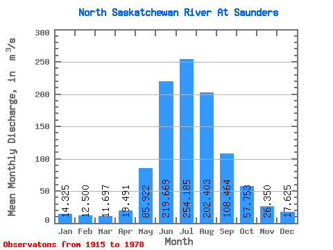
| Statistic | Jan | Feb | Mar | Apr | May | Jun | Jul | Aug | Sep | Oct | Nov | Dec | Annual |
|---|---|---|---|---|---|---|---|---|---|---|---|---|---|
| Mean | 14.32 | 12.50 | 11.70 | 19.49 | 85.92 | 219.67 | 254.19 | 202.40 | 108.46 | 57.75 | 26.35 | 17.62 | 98.22 |
| Standard Deviation | 2.53 | 2.28 | 2.00 | 4.39 | 29.93 | 77.44 | 92.81 | 76.50 | 26.62 | 17.78 | 5.98 | 5.23 | 9.40 |
| Min | 11.70 | 8.90 | 8.82 | 14.10 | 51.00 | 82.20 | 69.50 | 49.80 | 55.60 | 34.90 | 14.90 | 12.70 | 81.30 |
| Max | 19.90 | 16.10 | 15.10 | 25.60 | 184.00 | 340.00 | 430.00 | 365.00 | 170.00 | 101.00 | 35.80 | 26.70 | 106.92 |
| Coefficient of Variation | 0.18 | 0.18 | 0.17 | 0.23 | 0.35 | 0.35 | 0.36 | 0.38 | 0.24 | 0.31 | 0.23 | 0.30 | 0.10 |
 Return to R-Arctic Net Home Page