|
|
|||||||||||||||||
| Point ID: 4426 | Downloads | Plots | Site Data | Other Close Sites | Code: 05PF051 |
|
|
|||||||||||||||||
| Download | |
|---|---|
| Site Descriptor Information | Site Time Series Data |
| Link to all available data | |
| View: | Time Series | All |
| Units: | m3/s |
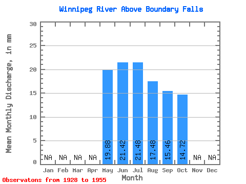
| Statistic | Jan | Feb | Mar | Apr | May | Jun | Jul | Aug | Sep | Oct | Nov | Dec | Annual |
|---|---|---|---|---|---|---|---|---|---|---|---|---|---|
| Mean | 19.87 | 21.42 | 21.48 | 17.48 | 15.46 | 14.71 | |||||||
| Standard Deviation | 11.83 | 13.05 | 9.13 | 7.21 | 4.00 | ||||||||
| Min | 19.87 | 9.28 | 7.82 | 7.59 | 7.32 | 7.95 | |||||||
| Max | 19.87 | 54.10 | 54.84 | 52.28 | 40.53 | 22.95 | |||||||
| Coefficient of Variation | 0.55 | 0.61 | 0.52 | 0.47 | 0.27 |
| Other Close Sites | ||||||
|---|---|---|---|---|---|---|
| PointID | Latitude | Longitude | Drainage Area | Source | Name | |
| 4454 | "ENGLISH RIVER AT CARIBOU FALLS" | 50.26 | 375212 | Hydat | ||
 Return to R-Arctic Net Home Page