|
|
|||||||||||||||||
| Point ID: 4454 | Downloads | Plots | Site Data | Other Close Sites | Code: 05QE005 |
|
|
|||||||||||||||||
| Download | |
|---|---|
| Site Descriptor Information | Site Time Series Data |
| Link to all available data | |
| View: | Time Series | All |
| Units: | m3/s |
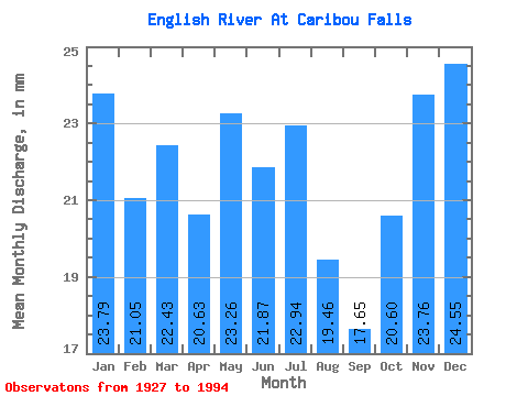
| Statistic | Jan | Feb | Mar | Apr | May | Jun | Jul | Aug | Sep | Oct | Nov | Dec | Annual |
|---|---|---|---|---|---|---|---|---|---|---|---|---|---|
| Mean | 23.78 | 21.23 | 22.43 | 20.63 | 23.26 | 21.87 | 22.94 | 19.46 | 17.65 | 20.60 | 23.76 | 24.54 | 262.65 |
| Standard Deviation | 5.18 | 4.40 | 5.33 | 7.27 | 10.88 | 10.94 | 12.66 | 9.89 | 7.77 | 8.33 | 7.48 | 5.89 | 69.89 |
| Min | 12.29 | 10.87 | 9.68 | 7.38 | 2.84 | 0.78 | 5.74 | 5.53 | 6.14 | 6.20 | 8.62 | 11.93 | 142.97 |
| Max | 32.41 | 28.23 | 33.03 | 34.34 | 54.79 | 54.52 | 59.91 | 50.74 | 38.21 | 47.93 | 40.94 | 38.81 | 420.45 |
| Coefficient of Variation | 0.22 | 0.21 | 0.24 | 0.35 | 0.47 | 0.50 | 0.55 | 0.51 | 0.44 | 0.40 | 0.32 | 0.24 | 0.27 |
| Other Close Sites | ||||||
|---|---|---|---|---|---|---|
| PointID | Latitude | Longitude | Drainage Area | Source | Name | |
| 4426 | "WINNIPEG RIVER ABOVE BOUNDARY FALLS" | 50.21 | 384712 | Hydat | ||
 Return to R-Arctic Net Home Page