|
|
|||||||||||||||||
| Point ID: 4426 | Downloads | Plots | Site Data | Other Close Sites | Code: 05PF051 |
|
|
|||||||||||||||||
| Download | |
|---|---|
| Site Descriptor Information | Site Time Series Data |
| Link to all available data | |
| View: | Time Series | All |
| Units: | mm |
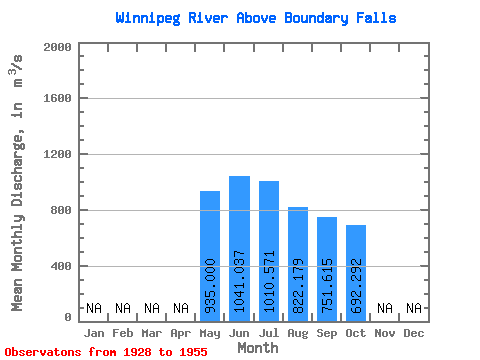
| Statistic | Jan | Feb | Mar | Apr | May | Jun | Jul | Aug | Sep | Oct | Nov | Dec | Annual |
|---|---|---|---|---|---|---|---|---|---|---|---|---|---|
| Mean | 935.00 | 1041.04 | 1010.57 | 822.18 | 751.62 | 692.29 | |||||||
| Standard Deviation | 574.90 | 614.25 | 429.62 | 350.29 | 188.02 | ||||||||
| Min | 935.00 | 451.00 | 368.00 | 357.00 | 356.00 | 374.00 | |||||||
| Max | 935.00 | 2630.00 | 2580.00 | 2460.00 | 1970.00 | 1080.00 | |||||||
| Coefficient of Variation | 0.55 | 0.61 | 0.52 | 0.47 | 0.27 |
| Other Close Sites | ||||||
|---|---|---|---|---|---|---|
| PointID | Latitude | Longitude | Drainage Area | Source | Name | |
| 4454 | "ENGLISH RIVER AT CARIBOU FALLS" | 50.26 | 375212 | Hydat | ||
 Return to R-Arctic Net Home Page