|
|
|||||||||||||||||
| Point ID: 4368 | Downloads | Plots | Site Data | Other Close Sites | Code: 04LG003 |
|
|
|||||||||||||||||
| Download | |
|---|---|
| Site Descriptor Information | Site Time Series Data |
| Link to all available data | |
| View: | Time Series | All |
| Units: | m3/s |
| Statistic | Jan | Feb | Mar | Apr | May | Jun | Jul | Aug | Sep | Oct | Nov | Dec | Annual |
|---|---|---|---|---|---|---|---|---|---|---|---|---|---|
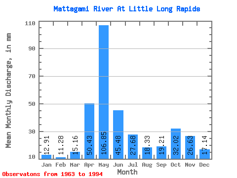
| Mean | 12.91 | 11.38 | 15.16 | 50.43 | 106.84 | 45.48 | 27.68 | 18.33 | 19.21 | 32.01 | 26.63 | 17.14 | 384.78 |
| Standard Deviation | 1.85 | 1.86 | 2.59 | 26.47 | 40.19 | 18.56 | 13.21 | 7.63 | 8.27 | 16.86 | 11.21 | 5.53 | 69.63 |
| Min | 8.18 | 7.88 | 10.34 | 13.15 | 27.55 | 19.50 | 8.64 | 5.99 | 5.81 | 7.27 | 6.82 | 5.90 | 240.64 |
| Max | 17.52 | 17.02 | 25.08 | 103.08 | 211.46 | 88.89 | 62.28 | 37.04 | 37.20 | 68.30 | 63.87 | 33.42 | 563.75 |
| Coefficient of Variation | 0.14 | 0.16 | 0.17 | 0.53 | 0.38 | 0.41 | 0.48 | 0.42 | 0.43 | 0.53 | 0.42 | 0.32 | 0.18 |
| Other Close Sites | ||||||
|---|---|---|---|---|---|---|
| PointID | Latitude | Longitude | Drainage Area | Source | Name | |
| 4366 | "MATTAGAMI RIVER AT SMOKY FALLS" | 50.06 | -594384 | Hydat | ||
 Return to R-Arctic Net Home Page