|
|
|||||||||||||||||
| Point ID: 4366 | Downloads | Plots | Site Data | Other Close Sites | Code: 04LG001 |
|
|
|||||||||||||||||
| Download | |
|---|---|
| Site Descriptor Information | Site Time Series Data |
| Link to all available data | |
| View: | Time Series | All |
| Units: | m3/s |
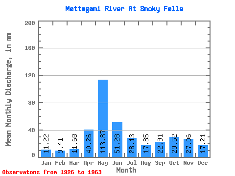
| Statistic | Jan | Feb | Mar | Apr | May | Jun | Jul | Aug | Sep | Oct | Nov | Dec | Annual |
|---|---|---|---|---|---|---|---|---|---|---|---|---|---|
| Mean | 11.22 | 9.49 | 11.68 | 40.26 | 113.86 | 51.28 | 28.12 | 17.85 | 22.91 | 29.52 | 27.06 | 17.20 | 380.88 |
| Standard Deviation | 2.69 | 1.65 | 3.15 | 23.52 | 40.39 | 22.87 | 12.94 | 7.47 | 16.67 | 19.69 | 12.19 | 7.20 | 81.45 |
| Min | 6.02 | 5.45 | 6.32 | 8.59 | 40.44 | 22.04 | 9.03 | 6.33 | 5.42 | 8.57 | 7.44 | 6.38 | 263.20 |
| Max | 19.60 | 13.22 | 22.23 | 106.82 | 221.50 | 125.49 | 61.66 | 35.50 | 73.05 | 94.15 | 57.74 | 38.74 | 690.39 |
| Coefficient of Variation | 0.24 | 0.17 | 0.27 | 0.58 | 0.35 | 0.45 | 0.46 | 0.42 | 0.73 | 0.67 | 0.45 | 0.42 | 0.21 |
| Other Close Sites | ||||||
|---|---|---|---|---|---|---|
| PointID | Latitude | Longitude | Drainage Area | Source | Name | |
| 4368 | "MATTAGAMI RIVER AT LITTLE LONG RAPIDS" | 50.00 | -594487 | Hydat | ||
 Return to R-Arctic Net Home Page