|
|
|||||||||||||||||
| Point ID: 4366 | Downloads | Plots | Site Data | Other Close Sites | Code: 04LG001 |
|
|
|||||||||||||||||
| Download | |
|---|---|
| Site Descriptor Information | Site Time Series Data |
| Link to all available data | |
|
|
| View: | Statistics | Time Series |
| Units: | m3/s |
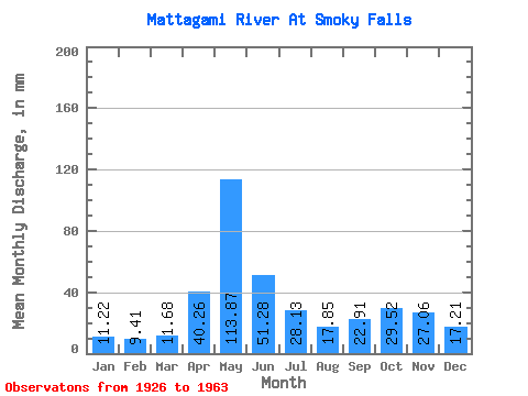
| Statistic | Jan | Feb | Mar | Apr | May | Jun | Jul | Aug | Sep | Oct | Nov | Dec | Annual |
|---|---|---|---|---|---|---|---|---|---|---|---|---|---|
| Mean | 11.22 | 9.49 | 11.68 | 40.26 | 113.86 | 51.28 | 28.12 | 17.85 | 22.91 | 29.52 | 27.06 | 17.20 | 380.88 |
| Standard Deviation | 2.69 | 1.65 | 3.15 | 23.52 | 40.39 | 22.87 | 12.94 | 7.47 | 16.67 | 19.69 | 12.19 | 7.20 | 81.45 |
| Min | 6.02 | 5.45 | 6.32 | 8.59 | 40.44 | 22.04 | 9.03 | 6.33 | 5.42 | 8.57 | 7.44 | 6.38 | 263.20 |
| Max | 19.60 | 13.22 | 22.23 | 106.82 | 221.50 | 125.49 | 61.66 | 35.50 | 73.05 | 94.15 | 57.74 | 38.74 | 690.39 |
| Coefficient of Variation | 0.24 | 0.17 | 0.27 | 0.58 | 0.35 | 0.45 | 0.46 | 0.42 | 0.73 | 0.67 | 0.45 | 0.42 | 0.21 |
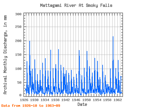
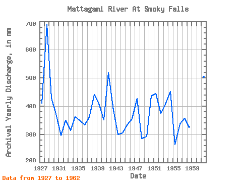
| Year | Jan | Feb | Mar | Apr | May | Jun | Jul | Aug | Sep | Oct | Nov | Dec | Annual | 1926 | 24.23 | 28.09 | 24.08 | 1927 | 14.05 | 9.56 | 13.04 | 71.41 | 129.66 | 42.50 | 22.54 | 16.90 | 13.37 | 42.06 | 22.86 | 14.36 | 410.72 | 1928 | 10.34 | 7.59 | 9.03 | 23.38 | 204.52 | 95.61 | 61.66 | 33.80 | 73.05 | 94.15 | 57.74 | 23.08 | 690.39 | 1929 | 13.66 | 8.23 | 10.57 | 44.00 | 101.87 | 72.16 | 31.41 | 18.29 | 28.98 | 40.83 | 45.19 | 14.97 | 429.44 | 1930 | 10.03 | 8.93 | 10.73 | 18.60 | 135.83 | 67.38 | 51.09 | 15.97 | 11.05 | 18.75 | 15.54 | 11.11 | 372.82 | 1931 | 9.03 | 7.31 | 8.49 | 35.33 | 81.81 | 27.49 | 17.98 | 9.57 | 9.34 | 23.08 | 42.95 | 24.70 | 296.20 | 1932 | 15.44 | 11.88 | 13.12 | 21.21 | 97.24 | 22.04 | 26.01 | 20.99 | 31.67 | 38.66 | 36.38 | 15.90 | 349.02 | 1933 | 12.19 | 11.53 | 10.50 | 51.02 | 124.25 | 37.80 | 14.43 | 12.50 | 10.61 | 10.19 | 12.77 | 7.70 | 314.60 | 1934 | 6.47 | 8.16 | 8.10 | 8.59 | 140.46 | 49.38 | 18.45 | 12.66 | 30.93 | 22.92 | 32.42 | 26.16 | 362.89 | 1935 | 11.04 | 9.21 | 11.35 | 32.27 | 94.93 | 48.40 | 30.25 | 24.54 | 16.96 | 41.52 | 18.82 | 10.88 | 348.57 | 1936 | 8.64 | 7.67 | 8.95 | 13.67 | 172.10 | 55.42 | 16.82 | 7.79 | 8.66 | 15.28 | 13.07 | 8.64 | 334.40 | 1937 | 7.21 | 7.38 | 9.18 | 31.07 | 104.19 | 27.11 | 33.57 | 35.42 | 17.25 | 37.28 | 32.49 | 20.14 | 360.05 | 1938 | 9.88 | 9.35 | 13.74 | 88.14 | 118.85 | 83.66 | 30.64 | 35.50 | 15.16 | 11.04 | 14.64 | 11.88 | 442.02 | 1939 | 11.35 | 9.28 | 9.49 | 15.69 | 173.65 | 57.29 | 34.27 | 17.06 | 23.90 | 30.25 | 18.90 | 9.88 | 408.29 | 1940 | 9.65 | 8.72 | 8.95 | 13.45 | 115.76 | 71.11 | 33.88 | 13.27 | 20.02 | 17.98 | 24.57 | 15.51 | 351.60 | 1941 | 10.50 | 9.70 | 11.50 | 62.15 | 107.27 | 36.45 | 22.07 | 27.48 | 64.39 | 82.58 | 46.98 | 38.74 | 518.27 | 1942 | 19.60 | 12.02 | 13.89 | 69.24 | 96.47 | 22.93 | 15.28 | 10.42 | 31.52 | 50.86 | 30.10 | 13.89 | 385.48 | 1943 | 9.88 | 8.30 | 8.80 | 18.15 | 86.44 | 69.77 | 33.65 | 16.21 | 11.35 | 10.42 | 16.81 | 10.03 | 299.00 | 1944 | 8.10 | 8.44 | 9.41 | 19.80 | 97.24 | 31.30 | 12.66 | 20.07 | 32.79 | 35.42 | 18.97 | 12.04 | 304.91 | 1945 | 9.65 | 8.37 | 20.91 | 69.54 | 49.93 | 55.65 | 30.64 | 14.12 | 15.24 | 18.21 | 28.68 | 14.28 | 335.53 | 1946 | 10.80 | 9.63 | 22.23 | 58.04 | 82.58 | 50.49 | 24.54 | 12.27 | 18.30 | 14.05 | 29.58 | 23.23 | 355.39 | 1947 | 12.43 | 9.70 | 11.58 | 14.04 | 170.56 | 125.49 | 33.65 | 17.44 | 11.73 | 8.57 | 7.44 | 6.38 | 427.42 | 1948 | 6.02 | 5.45 | 6.32 | 44.37 | 77.18 | 22.18 | 20.84 | 28.40 | 16.51 | 12.66 | 26.14 | 20.53 | 285.54 | 1949 | 11.65 | 10.62 | 11.65 | 45.27 | 104.96 | 35.48 | 15.97 | 9.41 | 11.50 | 14.74 | 12.77 | 8.95 | 292.18 | 1950 | 8.18 | 8.09 | 9.11 | 13.82 | 167.47 | 94.87 | 50.09 | 14.36 | 10.83 | 18.14 | 23.90 | 19.29 | 435.73 | 1951 | 12.12 | 10.41 | 13.35 | 106.82 | 93.38 | 32.42 | 27.32 | 15.59 | 12.32 | 44.30 | 47.51 | 29.64 | 444.68 | 1952 | 14.12 | 12.16 | 13.35 | 57.52 | 87.21 | 55.13 | 37.12 | 20.76 | 13.37 | 15.59 | 22.63 | 25.39 | 373.66 | 1953 | 13.81 | 11.81 | 16.05 | 44.22 | 142.00 | 51.02 | 24.85 | 10.88 | 27.04 | 22.23 | 17.70 | 27.17 | 407.16 | 1954 | 13.27 | 11.81 | 13.66 | 53.26 | 130.43 | 46.76 | 30.02 | 17.91 | 14.57 | 62.20 | 42.35 | 16.90 | 451.27 | 1955 | 12.43 | 10.34 | 11.27 | 68.72 | 55.18 | 26.74 | 9.03 | 6.33 | 5.42 | 24.62 | 21.21 | 11.65 | 263.20 | 1956 | 10.26 | 8.93 | 10.80 | 17.40 | 115.76 | 65.06 | 30.87 | 16.67 | 25.10 | 16.59 | 10.53 | 10.34 | 336.97 | 1957 | 9.57 | 8.86 | 11.11 | 59.53 | 78.72 | 35.85 | 46.85 | 10.88 | 15.31 | 17.44 | 42.13 | 21.45 | 357.13 | 1958 | 13.51 | 10.90 | 12.97 | 43.92 | 40.44 | 42.13 | 27.24 | 15.97 | 31.82 | 33.57 | 36.53 | 16.67 | 325.91 | 1959 | 11.50 | 9.49 | 11.11 | 21.44 | 102.64 | 32.20 | 10.65 | 13.12 | 16.73 | 31.49 | 29.06 | 14.51 | 302.64 | 1960 | 12.04 | 10.27 | 12.04 | 40.86 | 221.50 | 46.54 | 17.52 | 19.76 | 12.47 | 16.05 | 25.47 | 17.60 | 449.07 | 1961 | 11.11 | 8.58 | 10.57 | 39.96 | 103.42 | 64.39 | 60.35 | 27.32 | 64.31 | 54.80 | 35.18 | 25.08 | 503.49 | 1962 | 15.20 | 13.22 | 13.89 | 23.01 | 133.51 | 44.30 | 14.36 | 25.78 | 57.74 | 19.37 | 13.00 | 13.74 | 385.94 | 1963 | 10.34 | 9.14 | 11.19 | 30.70 | 73.32 | 52.96 | 22.00 | 14.97 | 16.36 |
|---|
| Other Close Sites | ||||||
|---|---|---|---|---|---|---|
| PointID | Latitude | Longitude | Drainage Area | Source | Name | |
| 4368 | "MATTAGAMI RIVER AT LITTLE LONG RAPIDS" | 50.00 | -594487 | Hydat | ||
 Return to R-Arctic Net Home Page