|
|
| Point ID: 4368 | Downloads | Plots | Site Data | Other Close Sites | Code: 04LG003 |
|
| Download | |
|---|---|
| Site Descriptor Information | Site Time Series Data |
| Link to all available data | |
|
|
|
| View: | Statistics | All |
| Units: | m3/s |
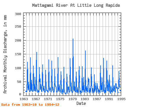
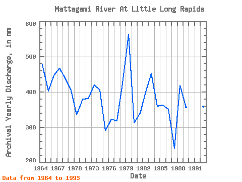
| Year | Jan | Feb | Mar | Apr | May | Jun | Jul | Aug | Sep | Oct | Nov | Dec | Annual | 1963 | 14.89 | 14.71 | 17.13 | 1964 | 13.51 | 13.01 | 14.89 | 64.76 | 125.03 | 69.47 | 35.12 | 20.53 | 23.31 | 49.01 | 33.84 | 16.75 | 478.10 | 1965 | 14.51 | 13.36 | 14.20 | 19.12 | 141.23 | 28.31 | 17.29 | 20.68 | 37.20 | 57.11 | 25.10 | 17.75 | 403.44 | 1966 | 14.89 | 15.75 | 16.28 | 50.42 | 110.36 | 54.45 | 18.91 | 18.91 | 17.18 | 67.92 | 33.31 | 31.33 | 448.24 | 1967 | 17.52 | 17.02 | 15.13 | 97.85 | 161.30 | 54.38 | 24.31 | 23.23 | 10.76 | 14.43 | 19.27 | 13.12 | 467.49 | 1968 | 12.50 | 10.48 | 14.74 | 101.59 | 51.55 | 51.32 | 62.28 | 22.84 | 28.98 | 41.44 | 24.28 | 15.82 | 437.70 | 1969 | 14.66 | 13.57 | 15.74 | 56.55 | 114.99 | 43.40 | 26.24 | 16.67 | 21.96 | 34.58 | 29.21 | 17.75 | 404.28 | 1970 | 11.96 | 11.25 | 12.43 | 18.75 | 94.93 | 58.56 | 38.59 | 19.68 | 19.20 | 17.44 | 18.00 | 16.05 | 335.61 | 1971 | 13.74 | 10.13 | 12.97 | 35.48 | 134.29 | 41.98 | 21.61 | 17.52 | 23.38 | 22.69 | 28.39 | 19.45 | 379.95 | 1972 | 14.43 | 12.02 | 14.97 | 16.88 | 128.88 | 63.49 | 32.41 | 19.68 | 18.75 | 31.95 | 18.38 | 12.04 | 381.99 | 1973 | 13.81 | 11.88 | 18.98 | 67.83 | 99.56 | 40.26 | 39.13 | 33.34 | 33.17 | 27.48 | 21.14 | 15.05 | 420.50 | 1974 | 12.19 | 11.32 | 17.52 | 17.33 | 142.78 | 61.55 | 28.79 | 16.59 | 17.25 | 40.29 | 28.39 | 13.89 | 405.72 | 1975 | 13.97 | 10.69 | 13.81 | 23.45 | 89.52 | 62.07 | 14.51 | 7.79 | 5.81 | 9.18 | 23.08 | 18.52 | 291.94 | 1976 | 12.89 | 9.84 | 16.21 | 103.08 | 101.10 | 25.10 | 15.13 | 11.96 | 7.69 | 7.27 | 6.82 | 5.90 | 322.79 | 1977 | 8.18 | 7.88 | 15.97 | 77.69 | 58.88 | 21.74 | 17.29 | 7.79 | 31.00 | 23.77 | 31.75 | 16.05 | 318.33 | 1978 | 11.88 | 10.20 | 13.58 | 13.15 | 138.15 | 72.53 | 51.40 | 16.75 | 19.50 | 47.23 | 19.27 | 13.27 | 424.29 | 1979 | 10.42 | 9.35 | 15.67 | 65.73 | 211.46 | 75.44 | 26.78 | 16.90 | 20.02 | 50.78 | 40.63 | 23.23 | 563.75 | 1980 | 13.51 | 11.32 | 14.05 | 51.47 | 87.98 | 38.10 | 18.52 | 10.50 | 11.58 | 29.71 | 17.03 | 10.26 | 313.33 | 1981 | 9.49 | 10.55 | 17.52 | 76.94 | 108.05 | 39.74 | 17.44 | 5.99 | 9.34 | 15.59 | 17.78 | 11.42 | 339.44 | 1982 | 10.03 | 10.69 | 13.51 | 22.11 | 108.05 | 19.87 | 34.42 | 12.35 | 27.11 | 68.30 | 51.77 | 24.16 | 400.11 | 1983 | 14.28 | 11.11 | 17.60 | 28.09 | 167.47 | 88.89 | 22.54 | 10.42 | 23.75 | 34.19 | 19.80 | 15.97 | 452.25 | 1984 | 13.35 | 11.67 | 15.20 | 64.46 | 56.65 | 50.20 | 61.97 | 16.52 | 8.66 | 13.58 | 26.14 | 21.61 | 359.56 | 1985 | 14.43 | 11.11 | 14.97 | 53.86 | 104.19 | 36.08 | 33.11 | 20.76 | 9.41 | 22.30 | 26.67 | 16.82 | 362.36 | 1986 | 11.27 | 9.63 | 13.35 | 67.08 | 78.72 | 19.50 | 14.66 | 22.38 | 26.59 | 45.61 | 26.82 | 16.21 | 351.00 | 1987 | 12.12 | 10.05 | 15.36 | 43.55 | 27.55 | 24.20 | 24.70 | 19.52 | 8.44 | 21.38 | 19.27 | 14.74 | 240.64 | 1988 | 11.58 | 10.13 | 10.34 | 54.98 | 111.91 | 26.97 | 13.81 | 37.04 | 20.91 | 25.62 | 63.87 | 33.42 | 419.44 | 1989 | 14.12 | 13.43 | 15.51 | 18.90 | 139.69 | 57.59 | 22.84 | 13.89 | 8.44 | 11.27 | 28.53 | 14.20 | 356.98 | 1990 | 12.35 | 10.34 | 25.08 | 70.36 | 128.88 | 55.28 | 36.43 | 17.52 | 17.55 | 57.96 | 44.37 | 20.14 | 494.47 | 1991 | 13.81 | 11.95 | 13.20 | 74.10 | 41.83 | 21.44 | 8.64 | 8.34 | 16.96 | 35.73 | 24.50 | 17.21 | 288.16 | 1992 | 13.35 | 10.27 | 12.81 | 38.17 | 111.13 | 22.11 | 15.82 | 19.14 | 27.94 | 36.97 | 30.25 | 22.61 | 358.95 | 1993 | 13.74 | 11.46 | 13.27 | 43.77 | 44.84 | 42.58 | 32.95 | 27.40 | 25.84 | 31.64 | 21.81 | 13.74 | 322.72 | 1994 | 11.58 | 25.77 | 91.07 | 43.32 | 30.41 | 35.58 | 17.70 | 17.06 | 17.93 | 12.81 |
|---|
| Other Close Sites | ||||||
|---|---|---|---|---|---|---|
| PointID | Latitude | Longitude | Drainage Area | Source | Name | |
| 4366 | "MATTAGAMI RIVER AT SMOKY FALLS" | 50.06 | -594384 | Hydat | ||
 Return to R-Arctic Net Home Page