|
|
| Point ID: 4368 | Downloads | Plots | Site Data | Other Close Sites | Code: 04LG003 |
|
| Download | |
|---|---|
| Site Descriptor Information | Site Time Series Data |
| Link to all available data | |
|
|
|
| View: | Statistics | All |
| Units: | mm |
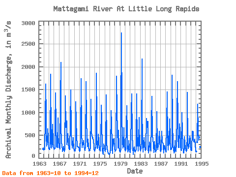
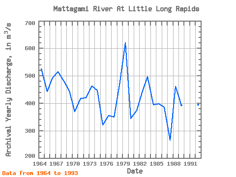
| Year | Jan | Feb | Mar | Apr | May | Jun | Jul | Aug | Sep | Oct | Nov | Dec | Annual | 1963 | 193.00 | 197.00 | 222.00 | 1964 | 175.00 | 185.00 | 193.00 | 867.00 | 1620.00 | 930.00 | 455.00 | 266.00 | 312.00 | 635.00 | 453.00 | 217.00 | 525.67 | 1965 | 188.00 | 190.00 | 184.00 | 256.00 | 1830.00 | 379.00 | 224.00 | 268.00 | 498.00 | 740.00 | 336.00 | 230.00 | 443.58 | 1966 | 193.00 | 224.00 | 211.00 | 675.00 | 1430.00 | 729.00 | 245.00 | 245.00 | 230.00 | 880.00 | 446.00 | 406.00 | 492.83 | 1967 | 227.00 | 242.00 | 196.00 | 1310.00 | 2090.00 | 728.00 | 315.00 | 301.00 | 144.00 | 187.00 | 258.00 | 170.00 | 514.00 | 1968 | 162.00 | 149.00 | 191.00 | 1360.00 | 668.00 | 687.00 | 807.00 | 296.00 | 388.00 | 537.00 | 325.00 | 205.00 | 481.25 | 1969 | 190.00 | 193.00 | 204.00 | 757.00 | 1490.00 | 581.00 | 340.00 | 216.00 | 294.00 | 448.00 | 391.00 | 230.00 | 444.50 | 1970 | 155.00 | 160.00 | 161.00 | 251.00 | 1230.00 | 784.00 | 500.00 | 255.00 | 257.00 | 226.00 | 241.00 | 208.00 | 369.00 | 1971 | 178.00 | 144.00 | 168.00 | 475.00 | 1740.00 | 562.00 | 280.00 | 227.00 | 313.00 | 294.00 | 380.00 | 252.00 | 417.75 | 1972 | 187.00 | 171.00 | 194.00 | 226.00 | 1670.00 | 850.00 | 420.00 | 255.00 | 251.00 | 414.00 | 246.00 | 156.00 | 420.00 | 1973 | 179.00 | 169.00 | 246.00 | 908.00 | 1290.00 | 539.00 | 507.00 | 432.00 | 444.00 | 356.00 | 283.00 | 195.00 | 462.33 | 1974 | 158.00 | 161.00 | 227.00 | 232.00 | 1850.00 | 824.00 | 373.00 | 215.00 | 231.00 | 522.00 | 380.00 | 180.00 | 446.08 | 1975 | 181.00 | 152.00 | 179.00 | 314.00 | 1160.00 | 831.00 | 188.00 | 101.00 | 77.80 | 119.00 | 309.00 | 240.00 | 320.98 | 1976 | 167.00 | 140.00 | 210.00 | 1380.00 | 1310.00 | 336.00 | 196.00 | 155.00 | 103.00 | 94.20 | 91.30 | 76.40 | 354.91 | 1977 | 106.00 | 112.00 | 207.00 | 1040.00 | 763.00 | 291.00 | 224.00 | 101.00 | 415.00 | 308.00 | 425.00 | 208.00 | 350.00 | 1978 | 154.00 | 145.00 | 176.00 | 176.00 | 1790.00 | 971.00 | 666.00 | 217.00 | 261.00 | 612.00 | 258.00 | 172.00 | 466.50 | 1979 | 135.00 | 133.00 | 203.00 | 880.00 | 2740.00 | 1010.00 | 347.00 | 219.00 | 268.00 | 658.00 | 544.00 | 301.00 | 619.83 | 1980 | 175.00 | 161.00 | 182.00 | 689.00 | 1140.00 | 510.00 | 240.00 | 136.00 | 155.00 | 385.00 | 228.00 | 133.00 | 344.50 | 1981 | 123.00 | 150.00 | 227.00 | 1030.00 | 1400.00 | 532.00 | 226.00 | 77.60 | 125.00 | 202.00 | 238.00 | 148.00 | 373.22 | 1982 | 130.00 | 152.00 | 175.00 | 296.00 | 1400.00 | 266.00 | 446.00 | 160.00 | 363.00 | 885.00 | 693.00 | 313.00 | 439.92 | 1983 | 185.00 | 158.00 | 228.00 | 376.00 | 2170.00 | 1190.00 | 292.00 | 135.00 | 318.00 | 443.00 | 265.00 | 207.00 | 497.25 | 1984 | 173.00 | 166.00 | 197.00 | 863.00 | 734.00 | 672.00 | 803.00 | 214.00 | 116.00 | 176.00 | 350.00 | 280.00 | 395.33 | 1985 | 187.00 | 158.00 | 194.00 | 721.00 | 1350.00 | 483.00 | 429.00 | 269.00 | 126.00 | 289.00 | 357.00 | 218.00 | 398.42 | 1986 | 146.00 | 137.00 | 173.00 | 898.00 | 1020.00 | 261.00 | 190.00 | 290.00 | 356.00 | 591.00 | 359.00 | 210.00 | 385.92 | 1987 | 157.00 | 143.00 | 199.00 | 583.00 | 357.00 | 324.00 | 320.00 | 253.00 | 113.00 | 277.00 | 258.00 | 191.00 | 264.58 | 1988 | 150.00 | 144.00 | 134.00 | 736.00 | 1450.00 | 361.00 | 179.00 | 480.00 | 280.00 | 332.00 | 855.00 | 433.00 | 461.17 | 1989 | 183.00 | 191.00 | 201.00 | 253.00 | 1810.00 | 771.00 | 296.00 | 180.00 | 113.00 | 146.00 | 382.00 | 184.00 | 392.50 | 1990 | 160.00 | 147.00 | 325.00 | 942.00 | 1670.00 | 740.00 | 472.00 | 227.00 | 235.00 | 751.00 | 594.00 | 261.00 | 543.67 | 1991 | 179.00 | 170.00 | 171.00 | 992.00 | 542.00 | 287.00 | 112.00 | 108.00 | 227.00 | 463.00 | 328.00 | 223.00 | 316.83 | 1992 | 173.00 | 146.00 | 166.00 | 511.00 | 1440.00 | 296.00 | 205.00 | 248.00 | 374.00 | 479.00 | 405.00 | 293.00 | 394.67 | 1993 | 178.00 | 163.00 | 172.00 | 586.00 | 581.00 | 570.00 | 427.00 | 355.00 | 346.00 | 410.00 | 292.00 | 178.00 | 354.83 | 1994 | 150.00 | 345.00 | 1180.00 | 580.00 | 394.00 | 461.00 | 237.00 | 221.00 | 240.00 | 166.00 |
|---|
| Other Close Sites | ||||||
|---|---|---|---|---|---|---|
| PointID | Latitude | Longitude | Drainage Area | Source | Name | |
| 4366 | "MATTAGAMI RIVER AT SMOKY FALLS" | 50.06 | -594384 | Hydat | ||
 Return to R-Arctic Net Home Page