|
|
|||||||||||||||||
| Point ID: 4367 | Downloads | Plots | Site Data | Other Close Sites | Code: 04LG002 |
|
|
|||||||||||||||||
| Download | |
|---|---|
| Site Descriptor Information | Site Time Series Data |
| Link to all available data | |
| View: | Time Series | All |
| Units: | m3/s |
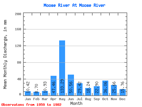
| Statistic | Jan | Feb | Mar | Apr | May | Jun | Jul | Aug | Sep | Oct | Nov | Dec | Annual |
|---|---|---|---|---|---|---|---|---|---|---|---|---|---|
| Mean | 10.42 | 8.78 | 10.93 | 47.46 | 133.27 | 50.56 | 29.42 | 18.23 | 22.90 | 36.06 | 25.66 | 15.76 | 408.06 |
| Standard Deviation | 2.83 | 2.14 | 2.65 | 30.64 | 41.04 | 15.32 | 15.44 | 7.97 | 14.92 | 19.86 | 10.68 | 5.26 | 79.14 |
| Min | 6.37 | 5.85 | 6.95 | 10.09 | 64.17 | 21.87 | 15.15 | 5.70 | 6.21 | 9.49 | 8.93 | 7.31 | 286.85 |
| Max | 16.80 | 13.88 | 17.02 | 105.66 | 236.61 | 81.51 | 76.64 | 35.91 | 66.85 | 70.85 | 49.60 | 27.58 | 571.51 |
| Coefficient of Variation | 0.27 | 0.24 | 0.24 | 0.65 | 0.31 | 0.30 | 0.53 | 0.44 | 0.65 | 0.55 | 0.42 | 0.33 | 0.19 |
| Other Close Sites | ||||||
|---|---|---|---|---|---|---|
| PointID | Latitude | Longitude | Drainage Area | Source | Name | |
| 4369 | "MOOSE RIVER ABOVE MOOSE RIVER" | 50.74 | -636431 | Hydat | ||
| 4381 | "ABITIBI RIVER AT ONAKAWANA" | 50.60 | -641576 | Hydat | ||
 Return to R-Arctic Net Home Page