|
|
|||||||||||||||||
| Point ID: 4381 | Downloads | Plots | Site Data | Other Close Sites | Code: 04ME003 |
|
|
|||||||||||||||||
| Download | |
|---|---|
| Site Descriptor Information | Site Time Series Data |
| Link to all available data | |
| View: | Time Series | All |
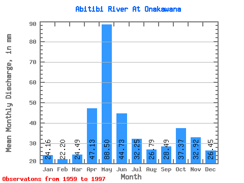
| Units: | m3/s |
| Statistic | Jan | Feb | Mar | Apr | May | Jun | Jul | Aug | Sep | Oct | Nov | Dec | Annual |
|---|---|---|---|---|---|---|---|---|---|---|---|---|---|
| Mean | 24.16 | 22.39 | 24.49 | 47.13 | 88.49 | 44.73 | 32.25 | 26.79 | 28.50 | 37.37 | 32.92 | 26.45 | 435.04 |
| Standard Deviation | 4.10 | 4.09 | 4.52 | 18.24 | 36.07 | 18.26 | 10.84 | 7.05 | 10.14 | 14.22 | 9.91 | 4.96 | 72.48 |
| Min | 15.19 | 13.49 | 15.87 | 16.68 | 27.95 | 24.04 | 20.74 | 16.07 | 14.33 | 16.26 | 19.23 | 19.18 | 305.08 |
| Max | 34.57 | 36.02 | 37.20 | 94.25 | 199.63 | 90.77 | 67.68 | 44.99 | 58.63 | 73.04 | 71.35 | 40.51 | 613.60 |
| Coefficient of Variation | 0.17 | 0.18 | 0.18 | 0.39 | 0.41 | 0.41 | 0.34 | 0.26 | 0.36 | 0.38 | 0.30 | 0.19 | 0.17 |
| Other Close Sites | ||||||
|---|---|---|---|---|---|---|
| PointID | Latitude | Longitude | Drainage Area | Source | Name | |
| 4367 | "MOOSE RIVER AT MOOSE RIVER" | 50.81 | -647140 | Hydat | ||
| 4369 | "MOOSE RIVER ABOVE MOOSE RIVER" | 50.74 | -636431 | Hydat | ||
 Return to R-Arctic Net Home Page