|
|
|||||||||||||||||
| Point ID: 4367 | Downloads | Plots | Site Data | Other Close Sites | Code: 04LG002 |
|
|
|||||||||||||||||
| Download | |
|---|---|
| Site Descriptor Information | Site Time Series Data |
| Link to all available data | |
| View: | Time Series | All |
| Units: | mm |
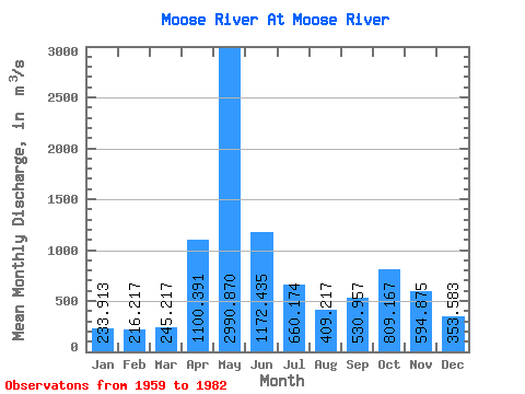
| Statistic | Jan | Feb | Mar | Apr | May | Jun | Jul | Aug | Sep | Oct | Nov | Dec | Annual |
|---|---|---|---|---|---|---|---|---|---|---|---|---|---|
| Mean | 233.91 | 216.22 | 245.22 | 1100.39 | 2990.87 | 1172.43 | 660.17 | 409.22 | 530.96 | 809.17 | 594.88 | 353.58 | 777.07 |
| Standard Deviation | 63.62 | 52.65 | 59.57 | 710.43 | 921.12 | 355.31 | 346.53 | 178.99 | 345.94 | 445.67 | 247.72 | 118.07 | 150.71 |
| Min | 143.00 | 144.00 | 156.00 | 234.00 | 1440.00 | 507.00 | 340.00 | 128.00 | 144.00 | 213.00 | 207.00 | 164.00 | 546.25 |
| Max | 377.00 | 342.00 | 382.00 | 2450.00 | 5310.00 | 1890.00 | 1720.00 | 806.00 | 1550.00 | 1590.00 | 1150.00 | 619.00 | 1088.33 |
| Coefficient of Variation | 0.27 | 0.24 | 0.24 | 0.65 | 0.31 | 0.30 | 0.53 | 0.44 | 0.65 | 0.55 | 0.42 | 0.33 | 0.19 |
| Other Close Sites | ||||||
|---|---|---|---|---|---|---|
| PointID | Latitude | Longitude | Drainage Area | Source | Name | |
| 4369 | "MOOSE RIVER ABOVE MOOSE RIVER" | 50.74 | -636431 | Hydat | ||
| 4381 | "ABITIBI RIVER AT ONAKAWANA" | 50.60 | -641576 | Hydat | ||
 Return to R-Arctic Net Home Page