|
|
|||||||||||||||||
| Point ID: 4349 | Downloads | Plots | Site Data | Code: 04JA002 |
|
|
|||||||||||||||||
| Download | |
|---|---|
| Site Descriptor Information | Site Time Series Data |
| Link to all available data | |
| View: | Time Series | All |
| Units: | m3/s |
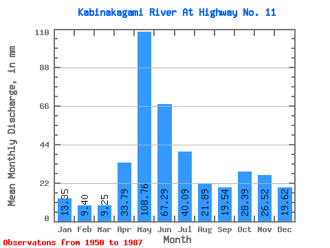
| Statistic | Jan | Feb | Mar | Apr | May | Jun | Jul | Aug | Sep | Oct | Nov | Dec | Annual |
|---|---|---|---|---|---|---|---|---|---|---|---|---|---|
| Mean | 13.35 | 9.48 | 9.25 | 33.79 | 108.74 | 67.28 | 40.09 | 21.89 | 19.54 | 28.38 | 26.52 | 19.62 | 399.51 |
| Standard Deviation | 4.95 | 3.04 | 2.74 | 17.82 | 31.99 | 20.02 | 14.89 | 9.80 | 11.44 | 16.57 | 15.17 | 8.65 | 72.70 |
| Min | 4.04 | 3.59 | 3.92 | 7.27 | 35.56 | 24.34 | 15.87 | 7.16 | 4.39 | 5.84 | 4.97 | 4.29 | 265.69 |
| Max | 25.22 | 16.07 | 15.73 | 72.00 | 187.03 | 119.31 | 78.64 | 51.29 | 51.02 | 69.71 | 68.57 | 43.50 | 618.54 |
| Coefficient of Variation | 0.37 | 0.32 | 0.30 | 0.53 | 0.29 | 0.30 | 0.37 | 0.45 | 0.58 | 0.58 | 0.57 | 0.44 | 0.18 |
 Return to R-Arctic Net Home Page