|
|
|||||||||||||||||
| Point ID: 4349 | Downloads | Plots | Site Data | Code: 04JA002 |
|
|
|||||||||||||||||
| Download | |
|---|---|
| Site Descriptor Information | Site Time Series Data |
| Link to all available data | |
| View: | Time Series | All |
| Units: | mm |
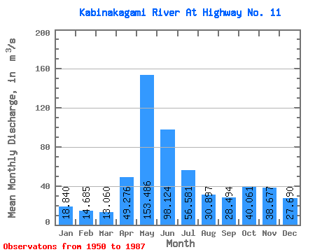
| Statistic | Jan | Feb | Mar | Apr | May | Jun | Jul | Aug | Sep | Oct | Nov | Dec | Annual |
|---|---|---|---|---|---|---|---|---|---|---|---|---|---|
| Mean | 18.84 | 14.69 | 13.06 | 49.28 | 153.49 | 98.12 | 56.58 | 30.90 | 28.49 | 40.06 | 38.68 | 27.69 | 47.85 |
| Standard Deviation | 6.99 | 4.71 | 3.87 | 25.99 | 45.16 | 29.20 | 21.02 | 13.83 | 16.68 | 23.38 | 22.12 | 12.21 | 8.71 |
| Min | 5.70 | 5.56 | 5.53 | 10.60 | 50.20 | 35.50 | 22.40 | 10.10 | 6.41 | 8.25 | 7.25 | 6.06 | 31.82 |
| Max | 35.60 | 24.90 | 22.20 | 105.00 | 264.00 | 174.00 | 111.00 | 72.40 | 74.40 | 98.40 | 100.00 | 61.40 | 74.08 |
| Coefficient of Variation | 0.37 | 0.32 | 0.30 | 0.53 | 0.29 | 0.30 | 0.37 | 0.45 | 0.58 | 0.58 | 0.57 | 0.44 | 0.18 |
 Return to R-Arctic Net Home Page