|
|
|||||||||||||||||
| Point ID: 4349 | Downloads | Plots | Site Data | Code: 04JA002 |
|
|
|||||||||||||||||
| Download | |
|---|---|
| Site Descriptor Information | Site Time Series Data |
| Link to all available data | |
|
|
| View: | Statistics | Time Series |
| Units: | m3/s |
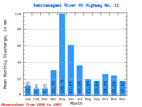
| Statistic | Jan | Feb | Mar | Apr | May | Jun | Jul | Aug | Sep | Oct | Nov | Dec | Annual |
|---|---|---|---|---|---|---|---|---|---|---|---|---|---|
| Mean | 13.35 | 9.48 | 9.25 | 33.79 | 108.74 | 67.28 | 40.09 | 21.89 | 19.54 | 28.38 | 26.52 | 19.62 | 399.51 |
| Standard Deviation | 4.95 | 3.04 | 2.74 | 17.82 | 31.99 | 20.02 | 14.89 | 9.80 | 11.44 | 16.57 | 15.17 | 8.65 | 72.70 |
| Min | 4.04 | 3.59 | 3.92 | 7.27 | 35.56 | 24.34 | 15.87 | 7.16 | 4.39 | 5.84 | 4.97 | 4.29 | 265.69 |
| Max | 25.22 | 16.07 | 15.73 | 72.00 | 187.03 | 119.31 | 78.64 | 51.29 | 51.02 | 69.71 | 68.57 | 43.50 | 618.54 |
| Coefficient of Variation | 0.37 | 0.32 | 0.30 | 0.53 | 0.29 | 0.30 | 0.37 | 0.45 | 0.58 | 0.58 | 0.57 | 0.44 | 0.18 |
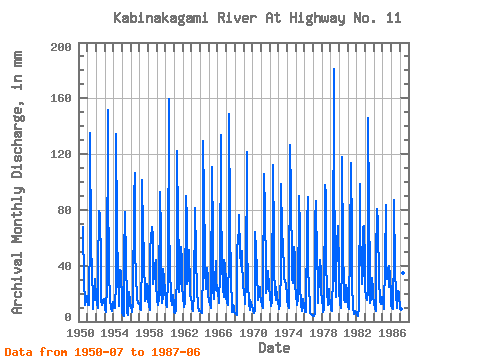
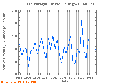
| Year | Jan | Feb | Mar | Apr | May | Jun | Jul | Aug | Sep | Oct | Nov | Dec | Annual | 1950 | 70.07 | 29.33 | 14.74 | 12.40 | 15.09 | 18.92 | 1951 | 14.45 | 11.36 | 12.19 | 66.10 | 139.57 | 54.10 | 37.27 | 15.66 | 8.64 | 21.40 | 29.07 | 31.31 | 439.45 | 1952 | 17.57 | 11.62 | 9.71 | 35.93 | 82.18 | 76.11 | 44.14 | 15.09 | 11.79 | 13.46 | 15.36 | 16.51 | 348.86 | 1953 | 9.21 | 6.65 | 7.72 | 25.99 | 156.57 | 97.37 | 37.97 | 15.37 | 10.42 | 9.07 | 7.82 | 14.24 | 396.52 | 1954 | 9.63 | 8.78 | 10.27 | 28.32 | 138.86 | 67.06 | 32.38 | 17.14 | 11.04 | 38.33 | 36.41 | 14.81 | 411.13 | 1955 | 6.80 | 4.38 | 4.09 | 46.35 | 80.77 | 43.68 | 15.87 | 7.16 | 4.39 | 16.93 | 21.19 | 14.66 | 265.69 | 1956 | 10.84 | 8.00 | 6.80 | 12.41 | 91.39 | 106.29 | 55.19 | 29.97 | 20.30 | 17.36 | 12.96 | 13.74 | 384.06 | 1957 | 11.76 | 8.59 | 8.43 | 47.45 | 104.85 | 65.07 | 49.52 | 15.66 | 14.61 | 16.79 | 26.88 | 25.36 | 393.74 | 1958 | 16.01 | 10.20 | 8.79 | 52.11 | 62.06 | 67.82 | 62.34 | 27.91 | 41.97 | 31.17 | 44.16 | 28.41 | 452.53 | 1959 | 15.52 | 11.23 | 12.19 | 15.84 | 95.64 | 62.81 | 24.73 | 14.03 | 17.76 | 38.82 | 30.31 | 22.67 | 360.27 | 1960 | 16.15 | 11.55 | 10.91 | 30.24 | 165.07 | 80.23 | 29.54 | 28.84 | 16.32 | 12.26 | 18.72 | 12.19 | 430.12 | 1961 | 6.67 | 6.02 | 8.15 | 37.78 | 126.11 | 70.63 | 47.75 | 21.75 | 31.20 | 55.05 | 43.34 | 28.55 | 480.88 | 1962 | 15.94 | 11.62 | 10.98 | 13.65 | 92.81 | 72.69 | 27.70 | 30.61 | 51.02 | 25.29 | 18.31 | 18.00 | 387.82 | 1963 | 12.61 | 8.52 | 7.72 | 20.23 | 83.60 | 81.60 | 49.73 | 20.83 | 14.06 | 10.77 | 7.68 | 7.58 | 323.95 | 1964 | 7.44 | 6.17 | 6.62 | 38.54 | 133.90 | 87.77 | 52.71 | 39.18 | 23.45 | 39.74 | 31.47 | 20.90 | 485.65 | 1965 | 14.31 | 11.49 | 10.13 | 18.38 | 114.06 | 60.96 | 24.80 | 16.79 | 27.70 | 44.99 | 29.49 | 24.23 | 395.75 | 1966 | 20.19 | 14.20 | 13.89 | 35.18 | 138.15 | 85.71 | 44.63 | 24.09 | 17.49 | 45.27 | 39.77 | 29.54 | 506.17 | 1967 | 18.42 | 12.72 | 12.40 | 50.33 | 153.74 | 70.63 | 28.34 | 14.59 | 7.06 | 12.26 | 11.38 | 7.30 | 397.77 | 1968 | 6.47 | 4.96 | 4.48 | 47.52 | 64.05 | 56.85 | 78.64 | 51.29 | 39.43 | 51.86 | 42.93 | 28.13 | 474.62 | 1969 | 21.40 | 15.04 | 13.18 | 28.39 | 125.40 | 54.58 | 28.62 | 13.96 | 8.30 | 16.22 | 12.21 | 11.69 | 347.54 | 1970 | 9.21 | 7.04 | 6.62 | 7.27 | 66.45 | 52.25 | 37.48 | 16.15 | 21.33 | 25.01 | 24.55 | 19.34 | 291.55 | 1971 | 15.16 | 11.17 | 9.92 | 17.83 | 109.10 | 79.54 | 38.40 | 20.90 | 24.41 | 32.16 | 36.41 | 26.36 | 420.04 | 1972 | 17.22 | 12.39 | 11.41 | 14.06 | 116.19 | 59.45 | 37.97 | 22.95 | 15.70 | 25.43 | 17.97 | 13.67 | 362.56 | 1973 | 11.69 | 8.65 | 12.33 | 39.15 | 102.02 | 63.84 | 56.25 | 39.18 | 30.17 | 30.18 | 26.47 | 20.48 | 438.54 | 1974 | 15.23 | 11.30 | 10.13 | 10.29 | 130.36 | 91.20 | 39.39 | 31.88 | 27.36 | 55.12 | 45.94 | 28.69 | 494.76 | 1975 | 18.77 | 12.59 | 11.90 | 16.18 | 92.81 | 65.49 | 27.28 | 11.90 | 7.68 | 8.50 | 16.11 | 11.05 | 299.53 | 1976 | 8.22 | 6.52 | 7.37 | 69.26 | 92.10 | 42.10 | 20.97 | 15.37 | 6.25 | 5.84 | 4.97 | 4.29 | 282.81 | 1977 | 4.04 | 3.59 | 5.33 | 72.00 | 89.27 | 41.90 | 33.23 | 13.74 | 34.63 | 45.77 | 35.45 | 22.03 | 400.13 | 1978 | 16.08 | 9.49 | 6.99 | 8.98 | 101.31 | 91.20 | 45.77 | 22.25 | 12.07 | 24.30 | 17.42 | 13.89 | 368.25 | 1979 | 11.12 | 7.42 | 7.94 | 35.25 | 187.03 | 119.31 | 40.38 | 18.07 | 31.20 | 56.54 | 68.23 | 38.19 | 618.54 | 1980 | 22.39 | 12.52 | 9.78 | 43.95 | 121.86 | 50.54 | 27.13 | 15.87 | 14.06 | 27.06 | 22.70 | 16.58 | 383.02 | 1981 | 10.77 | 8.26 | 9.92 | 54.17 | 117.61 | 62.13 | 27.77 | 10.70 | 5.05 | 6.10 | 7.47 | 6.29 | 325.38 | 1982 | 5.60 | 4.14 | 3.92 | 9.46 | 102.02 | 46.97 | 54.98 | 27.42 | 36.82 | 69.71 | 68.57 | 43.50 | 470.30 | 1983 | 25.22 | 16.07 | 15.73 | 20.85 | 150.90 | 82.29 | 33.87 | 14.03 | 16.11 | 32.52 | 23.18 | 18.49 | 447.38 | 1984 | 13.39 | 9.23 | 7.79 | 45.33 | 83.60 | 70.63 | 69.00 | 32.38 | 13.65 | 12.82 | 16.53 | 18.00 | 390.95 | 1985 | 14.17 | 10.01 | 9.56 | 42.03 | 86.43 | 46.56 | 31.17 | 37.48 | 24.96 | 41.30 | 33.53 | 19.13 | 394.99 | 1986 | 12.33 | 8.84 | 8.93 | 52.87 | 89.97 | 37.85 | 20.19 | 10.41 | 9.81 | 22.32 | 21.26 | 17.14 | 311.15 | 1987 | 11.83 | 8.39 | 8.15 | 40.53 | 35.56 | 24.34 |
|---|
 Return to R-Arctic Net Home Page