|
|
|||||||||||||||||
| Point ID: 263 | Downloads | Plots | Site Data | Code: 05BF013 |
|
|
|||||||||||||||||
| Download | |
|---|---|
| Site Descriptor Information | Site Time Series Data |
| Link to all available data | |
| View: | Time Series | All |
| Units: | m3/s |
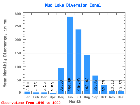
| Statistic | Jan | Feb | Mar | Apr | May | Jun | Jul | Aug | Sep | Oct | Nov | Dec | Annual |
|---|---|---|---|---|---|---|---|---|---|---|---|---|---|
| Mean | 7.85 | 4.80 | 5.26 | 2.50 | 95.57 | 284.87 | 236.98 | 142.41 | 66.94 | 32.77 | 10.14 | 10.53 | |
| Standard Deviation | 54.27 | 84.01 | 62.81 | 37.27 | 19.86 | 9.92 | 2.84 | ||||||
| Min | 7.85 | 4.80 | 5.26 | 2.50 | 10.16 | 139.43 | 122.82 | 69.72 | 39.68 | 19.21 | 8.13 | 10.53 | |
| Max | 7.85 | 4.80 | 5.26 | 2.50 | 241.02 | 472.82 | 368.46 | 234.56 | 124.24 | 52.91 | 12.16 | 10.53 | |
| Coefficient of Variation | 0.57 | 0.29 | 0.27 | 0.26 | 0.30 | 0.30 | 0.28 |
 Return to R-Arctic Net Home Page