|
|
|||||||||||||||||
| Point ID: 263 | Downloads | Plots | Site Data | Code: 05BF013 |
|
|
|||||||||||||||||
| Download | |
|---|---|
| Site Descriptor Information | Site Time Series Data |
| Link to all available data | |
| View: | Time Series | All |
| Units: | mm |
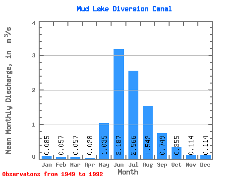
| Statistic | Jan | Feb | Mar | Apr | May | Jun | Jul | Aug | Sep | Oct | Nov | Dec | Annual |
|---|---|---|---|---|---|---|---|---|---|---|---|---|---|
| Mean | 0.09 | 0.06 | 0.06 | 0.03 | 1.03 | 3.19 | 2.57 | 1.54 | 0.75 | 0.35 | 0.11 | 0.11 | |
| Standard Deviation | 0.59 | 0.94 | 0.68 | 0.40 | 0.22 | 0.11 | 0.03 | ||||||
| Min | 0.09 | 0.06 | 0.06 | 0.03 | 0.11 | 1.56 | 1.33 | 0.76 | 0.44 | 0.21 | 0.09 | 0.11 | |
| Max | 0.09 | 0.06 | 0.06 | 0.03 | 2.61 | 5.29 | 3.99 | 2.54 | 1.39 | 0.57 | 0.14 | 0.11 | |
| Coefficient of Variation | 0.57 | 0.29 | 0.27 | 0.26 | 0.30 | 0.30 | 0.28 |
 Return to R-Arctic Net Home Page