|
|
|||||||||||||||||
| Point ID: 263 | Downloads | Plots | Site Data | Code: 05BF013 |
|
|
|||||||||||||||||
| Download | |
|---|---|
| Site Descriptor Information | Site Time Series Data |
| Link to all available data | |
|
|
| View: | Statistics | Time Series |
| Units: | m3/s |
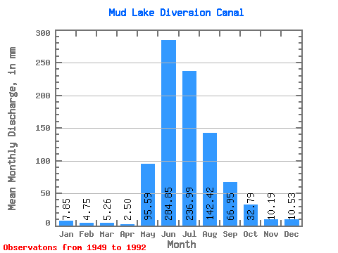
| Statistic | Jan | Feb | Mar | Apr | May | Jun | Jul | Aug | Sep | Oct | Nov | Dec | Annual |
|---|---|---|---|---|---|---|---|---|---|---|---|---|---|
| Mean | 7.85 | 4.80 | 5.26 | 2.50 | 95.57 | 284.87 | 236.98 | 142.41 | 66.94 | 32.77 | 10.14 | 10.53 | |
| Standard Deviation | 54.27 | 84.01 | 62.81 | 37.27 | 19.86 | 9.92 | 2.84 | ||||||
| Min | 7.85 | 4.80 | 5.26 | 2.50 | 10.16 | 139.43 | 122.82 | 69.72 | 39.68 | 19.21 | 8.13 | 10.53 | |
| Max | 7.85 | 4.80 | 5.26 | 2.50 | 241.02 | 472.82 | 368.46 | 234.56 | 124.24 | 52.91 | 12.16 | 10.53 | |
| Coefficient of Variation | 0.57 | 0.29 | 0.27 | 0.26 | 0.30 | 0.30 | 0.28 |
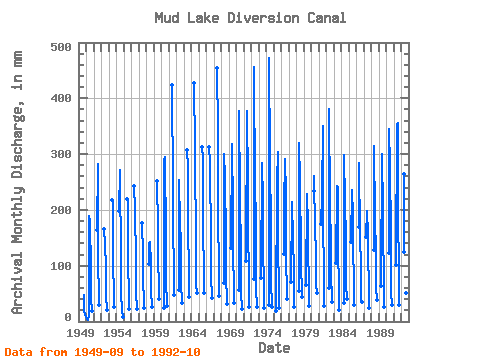
| Year | Jan | Feb | Mar | Apr | May | Jun | Jul | Aug | Sep | Oct | Nov | Dec | Annual | 1949 | 48.35 | 19.67 | 12.16 | 10.53 | 1950 | 7.85 | 4.80 | 5.26 | 2.50 | 10.16 | 188.59 | 184.69 | 95.11 | 39.68 | 19.21 | 1951 | 164.46 | 290.89 | 106.20 | 50.59 | 31.40 | 1952 | 166.25 | 141.29 | 102.50 | 46.03 | 20.87 | 1953 | 218.09 | 224.40 | 106.20 | 51.04 | 26.23 | 1954 | 197.53 | 280.73 | 106.20 | 52.02 | 20.22 | 8.13 | 1955 | 218.98 | 221.63 | 103.43 | 52.38 | 22.81 | 1956 | 243.11 | 208.70 | 109.89 | 51.75 | 23.09 | 1957 | 176.08 | 122.82 | 69.72 | 42.72 | 24.93 | 1958 | 107.12 | 139.43 | 147.75 | 108.97 | 53.90 | 26.50 | 1959 | 252.05 | 171.76 | 95.11 | 80.98 | 40.91 | 1960 | 25.12 | 286.91 | 303.81 | 152.37 | 74.72 | 28.16 | 1961 | 424.55 | 244.71 | 201.31 | 67.75 | 48.67 | 1962 | 58.82 | 252.94 | 182.84 | 144.98 | 70.52 | 34.35 | 1963 | 306.57 | 285.35 | 141.29 | 121.56 | 45.06 | 1964 | 427.23 | 320.44 | 130.21 | 65.52 | 51.90 | 1965 | 311.93 | 300.12 | 205.93 | 54.52 | 52.64 | 1966 | 312.83 | 292.73 | 144.06 | 81.25 | 43.96 | 1967 | 454.05 | 349.99 | 187.46 | 100.11 | 47.37 | 1968 | 70.92 | 299.42 | 266.88 | 149.60 | 86.43 | 32.41 | 1969 | 136.67 | 317.30 | 208.70 | 122.82 | 62.30 | 33.71 | 1970 | 59.19 | 378.07 | 234.56 | 124.67 | 52.64 | 22.62 | 1971 | 111.74 | 377.18 | 252.10 | 193.92 | 58.63 | 27.24 | 1972 | 78.58 | 455.83 | 241.02 | 196.69 | 60.33 | 26.50 | 1973 | 79.88 | 283.33 | 225.32 | 135.75 | 65.60 | 24.56 | 1974 | 30.20 | 472.82 | 298.27 | 171.76 | 74.99 | 27.70 | 1975 | 18.56 | 252.05 | 313.97 | 144.06 | 53.09 | 25.49 | 1976 | 125.59 | 207.36 | 301.04 | 234.56 | 124.24 | 41.46 | 1977 | 73.41 | 214.51 | 153.29 | 171.76 | 74.90 | 27.52 | 1978 | 55.87 | 319.08 | 261.34 | 124.67 | 109.94 | 44.60 | 1979 | 67.23 | 227.92 | 178.23 | 131.13 | 68.64 | 29.46 | 1980 | 241.02 | 260.09 | 165.30 | 132.98 | 67.93 | 52.91 | 1981 | 180.07 | 224.34 | 361.07 | 195.77 | 76.33 | 28.54 | 1982 | 62.89 | 381.65 | 216.09 | 142.21 | 89.38 | 37.03 | 1983 | 108.04 | 243.11 | 247.48 | 148.68 | 45.94 | 22.07 | 1984 | 34.17 | 298.53 | 218.86 | 152.37 | 66.23 | 40.91 | 1985 | 146.83 | 235.96 | 196.69 | 124.67 | 83.03 | 31.21 | 1986 | 174.53 | 284.23 | 158.83 | 98.81 | 40.67 | 36.66 | 1987 | 156.99 | 197.53 | 161.60 | 119.12 | 67.21 | 24.47 | 1988 | 132.05 | 313.72 | 193.92 | 125.59 | 62.30 | 40.26 | 1989 | 65.66 | 300.31 | 202.24 | 165.30 | 75.08 | 26.50 | 1990 | 126.51 | 345.00 | 288.12 | 159.76 | 51.84 | 31.21 | 1991 | 104.35 | 353.94 | 368.46 | 216.09 | 71.86 | 29.83 | 1992 | 129.28 | 264.56 | 202.24 | 130.21 | 50.32 | 48.85 |
|---|
 Return to R-Arctic Net Home Page