|
|
| Point ID: 3004 | Downloads | Plots | Site Data | Code: 05OD033 |
|
| Download | |
|---|---|
| Site Descriptor Information | Site Time Series Data |
| Link to all available data | |
|
|
|
| View: | Statistics | All |
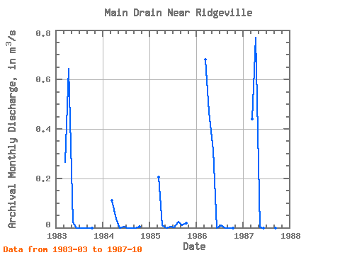
| Units: | mm |
| Year | Jan | Feb | Mar | Apr | May | Jun | Jul | Aug | Sep | Oct | Nov | Dec | Annual | 1983 | 0.27 | 0.64 | 0.02 | 0.00 | 0.00 | 0.00 | 0.00 | 0.00 | 1984 | 0.11 | 0.04 | 0.00 | 0.00 | 0.00 | 0.00 | 0.00 | 0.00 | 1985 | 0.20 | 0.01 | 0.00 | 0.00 | 0.00 | 0.02 | 0.01 | 0.02 | 1986 | 0.68 | 0.47 | 0.31 | 0.00 | 0.01 | 0.00 | 0.00 | 0.00 | 1987 | 0.44 | 0.77 | 0.00 | 0.00 | 0.00 | 0.00 | 0.00 | 0.00 |
|---|
 Return to R-Arctic Net Home Page