|
|
|||||||||||||||||
| Point ID: 3004 | Downloads | Plots | Site Data | Code: 05OD033 |
|
|
|||||||||||||||||
| Download | |
|---|---|
| Site Descriptor Information | Site Time Series Data |
| Link to all available data | |
| View: | Time Series | All |
| Units: | mm |
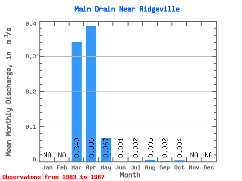
| Statistic | Jan | Feb | Mar | Apr | May | Jun | Jul | Aug | Sep | Oct | Nov | Dec | Annual |
|---|---|---|---|---|---|---|---|---|---|---|---|---|---|
| Mean | 0.34 | 0.39 | 0.07 | 0.00 | 0.00 | 0.01 | 0.00 | 0.00 | |||||
| Standard Deviation | 0.23 | 0.35 | 0.14 | 0.00 | 0.00 | 0.01 | 0.00 | 0.01 | |||||
| Min | 0.11 | 0.01 | 0.00 | 0.00 | 0.00 | 0.00 | 0.00 | 0.00 | |||||
| Max | 0.68 | 0.77 | 0.31 | 0.00 | 0.01 | 0.02 | 0.01 | 0.02 | |||||
| Coefficient of Variation | 0.66 | 0.90 | 2.06 | 1.37 | 1.99 | 2.24 | 2.24 | 1.88 |
 Return to R-Arctic Net Home Page