|
|
| Point ID: 3004 | Downloads | Plots | Site Data | Code: 05OD033 |
|
| Download | |
|---|---|
| Site Descriptor Information | Site Time Series Data |
| Link to all available data | |
|
|
|
| View: | Statistics | All |
| Units: | m3/s |
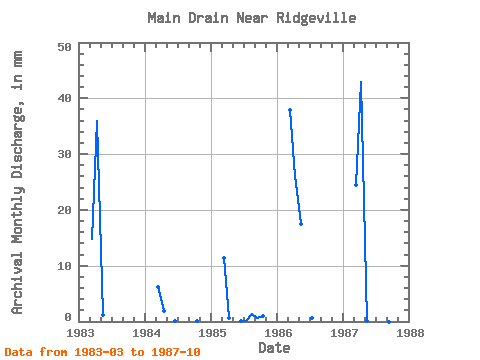
| Year | Jan | Feb | Mar | Apr | May | Jun | Jul | Aug | Sep | Oct | Nov | Dec | Annual | 1983 | 15.26 | 35.90 | 1.21 | 0.00 | 0.00 | 0.00 | 0.00 | 0.00 | 1984 | 6.39 | 1.95 | 0.00 | 0.17 | 0.00 | 0.00 | 0.00 | 0.17 | 1985 | 11.75 | 0.56 | 0.00 | 0.17 | 0.06 | 1.38 | 0.56 | 1.09 | 1986 | 39.22 | 26.14 | 18.08 | 0.00 | 0.58 | 0.00 | 0.00 | 0.00 | 1987 | 25.28 | 42.98 | 0.06 | 0.00 | 0.00 | 0.00 | 0.00 | 0.00 |
|---|
 Return to R-Arctic Net Home Page