|
|
| Point ID: 131 | Downloads | Plots | Site Data | Code: 05AE012 |
|
| Download | |
|---|---|
| Site Descriptor Information | Site Time Series Data |
| Link to all available data | |
|
|
|
| View: | Statistics | All |
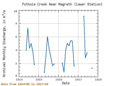
| Units: | mm |
| Year | Jan | Feb | Mar | Apr | May | Jun | Jul | Aug | Sep | Oct | Nov | Dec | Annual | 1914 | 3.91 | 7.33 | 4.30 | 5.01 | 3.78 | 1.86 | 1915 | 0.65 | 2.81 | 6.04 | 4.17 | 2.96 | 1.66 | 1.90 | 1916 | 2.07 | 0.70 | 4.00 | 5.05 | 4.65 | 5.44 | 5.35 | 1.62 | 1917 | 9.10 | 2.84 | 3.57 | 2.26 | 1.14 | 1.29 | 1.97 |
|---|
 Return to R-Arctic Net Home Page