|
|
|||||||||||||||||
| Point ID: 131 | Downloads | Plots | Site Data | Code: 05AE012 |
|
|
|||||||||||||||||
| Download | |
|---|---|
| Site Descriptor Information | Site Time Series Data |
| Link to all available data | |
| View: | Time Series | All |
| Units: | mm |
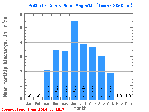
| Statistic | Jan | Feb | Mar | Apr | May | Jun | Jul | Aug | Sep | Oct | Nov | Dec | Annual |
|---|---|---|---|---|---|---|---|---|---|---|---|---|---|
| Mean | 2.07 | 3.48 | 3.39 | 5.50 | 3.84 | 3.64 | 3.02 | 1.84 | |||||
| Standard Deviation | 4.86 | 0.65 | 1.59 | 1.08 | 1.99 | 1.90 | 0.15 | ||||||
| Min | 2.07 | 0.65 | 2.81 | 3.57 | 2.26 | 1.14 | 1.29 | 1.62 | |||||
| Max | 2.07 | 9.10 | 4.00 | 7.33 | 4.65 | 5.44 | 5.35 | 1.97 | |||||
| Coefficient of Variation | 1.40 | 0.19 | 0.29 | 0.28 | 0.55 | 0.63 | 0.08 |
 Return to R-Arctic Net Home Page