|
|
| Point ID: 131 | Downloads | Plots | Site Data | Code: 05AE012 |
|
| Download | |
|---|---|
| Site Descriptor Information | Site Time Series Data |
| Link to all available data | |
|
|
|
| View: | Statistics | All |
| Units: | m3/s |
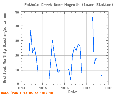
| Year | Jan | Feb | Mar | Apr | May | Jun | Jul | Aug | Sep | Oct | Nov | Dec | Annual | 1914 | 19.32 | 35.05 | 21.25 | 24.75 | 18.08 | 9.19 | 1915 | 3.09 | 13.88 | 28.89 | 20.60 | 14.62 | 7.94 | 9.39 | 1916 | 10.23 | 3.36 | 19.76 | 24.15 | 22.98 | 26.88 | 25.59 | 8.00 | 1917 | 43.52 | 14.03 | 17.07 | 11.17 | 5.63 | 6.17 | 9.73 |
|---|
 Return to R-Arctic Net Home Page