|
|
| Point ID: 5818 | Downloads | Plots | Site Data | Code: 09DC001 |
|
| Download | |
|---|---|
| Site Descriptor Information | Site Time Series Data |
| Link to all available data | |
|
|
|
| View: | Statistics | All |
| Units: | m3/s |
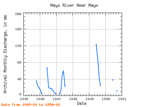
| Year | Jan | Feb | Mar | Apr | May | Jun | Jul | Aug | Sep | Oct | Nov | Dec | Annual | 1945 | 37.45 | 24.31 | 19.67 | 1946 | 12.92 | 4.98 | 66.64 | 20.62 | 17.77 | 17.43 | 13.04 | 8.15 | 4.92 | 1947 | 4.09 | 9.92 | 52.38 | 59.64 | 23.11 | 1949 | 122.72 | 90.06 | 44.20 | 24.43 | 1950 | 37.73 | 19.79 | 12.44 | 11.26 | 12.80 |
|---|
 Return to R-Arctic Net Home Page