|
|
|||||||||||||||||
| Point ID: 5818 | Downloads | Plots | Site Data | Code: 09DC001 |
|
|
|||||||||||||||||
| Download | |
|---|---|
| Site Descriptor Information | Site Time Series Data |
| Link to all available data | |
| View: | Time Series | All |
| Units: | m3/s |
| Statistic | Jan | Feb | Mar | Apr | May | Jun | Jul | Aug | Sep | Oct | Nov | Dec | Annual |
|---|---|---|---|---|---|---|---|---|---|---|---|---|---|
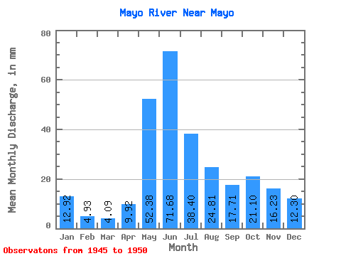
| Mean | 12.92 | 4.98 | 4.09 | 9.92 | 52.38 | 71.68 | 38.39 | 24.80 | 17.71 | 21.09 | 16.23 | 12.29 | |
| Standard Deviation | 36.18 | 34.47 | 17.01 | 6.59 | 14.16 | 11.43 | 10.43 | ||||||
| Min | 12.92 | 4.98 | 4.09 | 9.92 | 52.38 | 37.73 | 19.79 | 12.44 | 11.26 | 12.80 | 8.15 | 4.92 | |
| Max | 12.92 | 4.98 | 4.09 | 9.92 | 52.38 | 122.72 | 90.06 | 44.20 | 24.43 | 37.45 | 24.31 | 19.67 | |
| Coefficient of Variation | 0.51 | 0.90 | 0.69 | 0.37 | 0.67 | 0.70 | 0.85 |
 Return to R-Arctic Net Home Page