|
|
| Point ID: 5818 | Downloads | Plots | Site Data | Code: 09DC001 |
|
| Download | |
|---|---|
| Site Descriptor Information | Site Time Series Data |
| Link to all available data | |
|
|
|
| View: | Statistics | All |
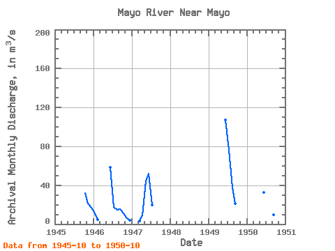
| Units: | mm |
| Year | Jan | Feb | Mar | Apr | May | Jun | Jul | Aug | Sep | Oct | Nov | Dec | Annual | 1945 | 31.60 | 21.20 | 16.60 | 1946 | 10.90 | 4.61 | 58.10 | 17.40 | 15.00 | 15.20 | 11.00 | 7.11 | 4.15 | 1947 | 3.45 | 8.65 | 44.20 | 52.00 | 19.50 | 1949 | 107.00 | 76.00 | 37.30 | 21.30 | 1950 | 32.90 | 16.70 | 10.50 | 9.82 | 10.80 |
|---|
 Return to R-Arctic Net Home Page