|
|
| Point ID: 5483 | Downloads | Plots | Site Data | Code: 05MA008 |
|
| Download | |
|---|---|
| Site Descriptor Information | Site Time Series Data |
| Link to all available data | |
|
|
|
| View: | Statistics | All |
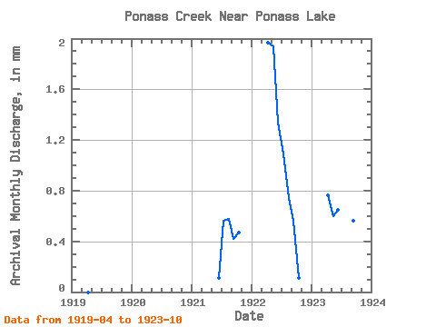
| Units: | m3/s |
| Year | Jan | Feb | Mar | Apr | May | Jun | Jul | Aug | Sep | Oct | Nov | Dec | Annual | 1919 | 0.00 | 0.00 | 0.00 | 0.00 | 0.00 | 0.00 | 0.00 | 1920 | 0.00 | 0.00 | 0.00 | 0.00 | 0.00 | 0.00 | 0.00 | 1921 | 0.00 | 0.05 | 0.27 | 0.28 | 0.20 | 0.23 | 1922 | 0.91 | 0.93 | 0.62 | 0.53 | 0.35 | 0.26 | 0.05 | 1923 | 0.35 | 0.29 | 0.30 | 0.53 | 0.51 | 0.26 | 0.09 |
|---|
 Return to R-Arctic Net Home Page