|
|
| Point ID: 5483 | Downloads | Plots | Site Data | Code: 05MA008 |
|
| Download | |
|---|---|
| Site Descriptor Information | Site Time Series Data |
| Link to all available data | |
|
|
|
| View: | Statistics | All |
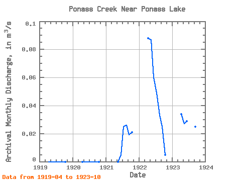
| Units: | mm |
| Year | Jan | Feb | Mar | Apr | May | Jun | Jul | Aug | Sep | Oct | Nov | Dec | Annual | 1919 | 0.00 | 0.00 | 0.00 | 0.00 | 0.00 | 0.00 | 0.00 | 1920 | 0.00 | 0.00 | 0.00 | 0.00 | 0.00 | 0.00 | 0.00 | 1921 | 0.00 | 0.01 | 0.03 | 0.03 | 0.02 | 0.02 | 1922 | 0.09 | 0.09 | 0.06 | 0.05 | 0.03 | 0.03 | 0.01 | 1923 | 0.03 | 0.03 | 0.03 | 0.05 | 0.05 | 0.03 | 0.01 |
|---|
 Return to R-Arctic Net Home Page