|
|
| Point ID: 534 | Downloads | Plots | Site Data | Code: 05FA017 |
|
| Download | |
|---|---|
| Site Descriptor Information | Site Time Series Data |
| Link to all available data | |
|
|
|
| View: | Statistics | All |
| Units: | m3/s |
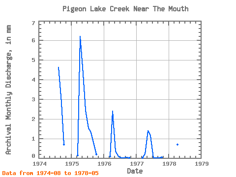
| Year | Jan | Feb | Mar | Apr | May | Jun | Jul | Aug | Sep | Oct | Nov | Dec | Annual | 1974 | 4.76 | 2.81 | 0.70 | 1975 | 0.13 | 6.19 | 4.43 | 2.44 | 1.57 | 1.36 | 0.70 | 0.20 | 1976 | 0.10 | 2.39 | 0.36 | 0.08 | 0.01 | 0.01 | 0.03 | 0.01 | 1977 | 0.01 | 0.21 | 1.45 | 1.15 | 0.01 | 0.01 | 0.02 | 0.03 | 1978 | 1.03 | 0.68 | 0.13 |
|---|
 Return to R-Arctic Net Home Page