|
|
|||||||||||||||||
| Point ID: 534 | Downloads | Plots | Site Data | Code: 05FA017 |
|
|
|||||||||||||||||
| Download | |
|---|---|
| Site Descriptor Information | Site Time Series Data |
| Link to all available data | |
| View: | Time Series | All |
| Units: | m3/s |
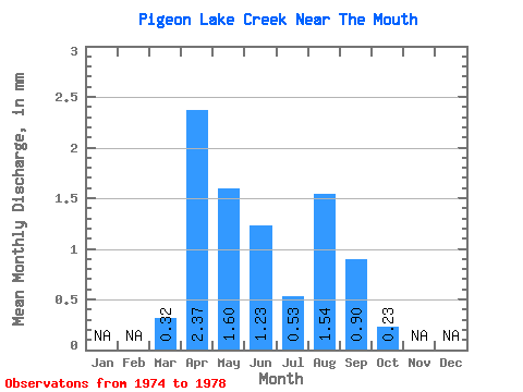
| Statistic | Jan | Feb | Mar | Apr | May | Jun | Jul | Aug | Sep | Oct | Nov | Dec | Annual |
|---|---|---|---|---|---|---|---|---|---|---|---|---|---|
| Mean | 0.32 | 2.37 | 1.59 | 1.23 | 0.53 | 1.54 | 0.89 | 0.23 | |||||
| Standard Deviation | 0.48 | 2.71 | 1.98 | 1.18 | 0.90 | 2.24 | 1.32 | 0.32 | |||||
| Min | 0.01 | 0.21 | 0.13 | 0.08 | 0.01 | 0.01 | 0.02 | 0.01 | |||||
| Max | 1.03 | 6.19 | 4.43 | 2.44 | 1.57 | 4.76 | 2.81 | 0.70 | |||||
| Coefficient of Variation | 1.50 | 1.15 | 1.24 | 0.97 | 1.70 | 1.46 | 1.49 | 1.39 |
 Return to R-Arctic Net Home Page