|
|
| Point ID: 534 | Downloads | Plots | Site Data | Code: 05FA017 |
|
| Download | |
|---|---|
| Site Descriptor Information | Site Time Series Data |
| Link to all available data | |
|
|
|
| View: | Statistics | All |
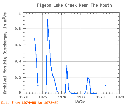
| Units: | mm |
| Year | Jan | Feb | Mar | Apr | May | Jun | Jul | Aug | Sep | Oct | Nov | Dec | Annual | 1974 | 0.68 | 0.42 | 0.10 | 1975 | 0.02 | 0.91 | 0.63 | 0.36 | 0.23 | 0.20 | 0.10 | 0.03 | 1976 | 0.01 | 0.35 | 0.05 | 0.01 | 0.00 | 0.00 | 0.00 | 0.00 | 1977 | 0.00 | 0.03 | 0.21 | 0.17 | 0.00 | 0.00 | 0.00 | 0.00 | 1978 | 0.15 | 0.10 | 0.02 |
|---|
 Return to R-Arctic Net Home Page