|
|
| Point ID: 5109 | Downloads | Plots | Site Data | Code: 03CD002 |
|
| Download | |
|---|---|
| Site Descriptor Information | Site Time Series Data |
| Link to all available data | |
|
|
|
| View: | Statistics | All |
| Units: | m3/s |
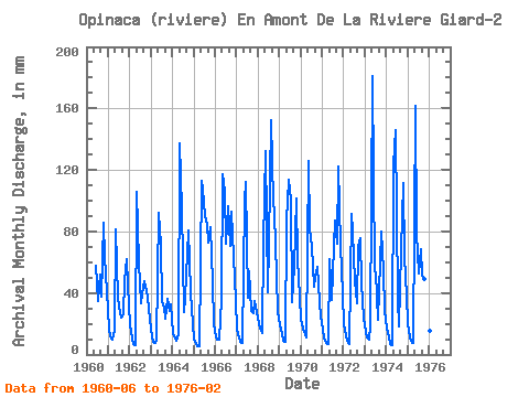
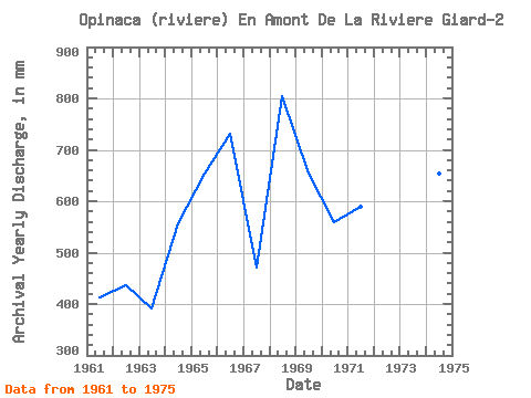
| Year | Jan | Feb | Mar | Apr | May | Jun | Jul | Aug | Sep | Oct | Nov | Dec | Annual | 1960 | 57.80 | 35.76 | 53.78 | 37.83 | 88.30 | 63.68 | 42.92 | 1961 | 17.44 | 10.81 | 10.28 | 15.20 | 83.96 | 37.27 | 31.92 | 24.46 | 26.34 | 49.87 | 62.07 | 46.10 | 413.90 | 1962 | 19.83 | 9.63 | 7.18 | 5.74 | 109.29 | 60.11 | 34.74 | 41.40 | 47.50 | 42.78 | 37.06 | 23.59 | 436.80 | 1963 | 12.09 | 7.91 | 7.74 | 8.83 | 95.54 | 71.45 | 36.04 | 31.56 | 22.98 | 37.49 | 28.51 | 33.51 | 391.66 | 1964 | 14.26 | 9.83 | 9.19 | 13.38 | 141.86 | 95.27 | 28.30 | 38.29 | 65.57 | 83.23 | 40.77 | 20.27 | 558.13 | 1965 | 10.28 | 6.51 | 5.82 | 5.11 | 116.53 | 107.88 | 92.64 | 87.58 | 72.86 | 85.41 | 46.66 | 20.84 | 654.52 | 1966 | 11.80 | 8.97 | 9.77 | 35.87 | 120.87 | 105.78 | 74.55 | 99.88 | 70.75 | 96.26 | 63.75 | 36.98 | 731.92 | 1967 | 16.50 | 10.42 | 8.83 | 7.78 | 103.50 | 112.09 | 38.36 | 56.24 | 28.23 | 27.94 | 34.68 | 28.23 | 471.27 | 1968 | 20.99 | 15.83 | 14.69 | 72.86 | 136.79 | 40.42 | 74.55 | 157.06 | 99.48 | 95.54 | 51.35 | 28.81 | 804.00 | 1969 | 19.54 | 12.86 | 9.41 | 8.06 | 89.75 | 113.49 | 104.22 | 35.32 | 57.16 | 104.95 | 62.00 | 39.23 | 653.31 | 1970 | 23.59 | 15.70 | 13.39 | 11.21 | 130.28 | 81.26 | 72.38 | 45.45 | 50.65 | 58.70 | 33.98 | 25.55 | 559.34 | 1971 | 16.79 | 10.16 | 7.46 | 6.58 | 64.13 | 35.24 | 54.07 | 89.75 | 72.16 | 125.94 | 71.45 | 40.10 | 590.18 | 1972 | 20.41 | 11.80 | 9.26 | 6.72 | 94.09 | 79.86 | 49.58 | 34.31 | 69.63 | 78.17 | 45.88 | 24.25 | 522.30 | 1973 | 15.05 | 10.35 | 9.70 | 18.77 | 186.74 | 54.01 | 55.51 | 23.59 | 59.97 | 82.51 | 54.64 | 29.17 | 596.37 | 1974 | 17.66 | 10.29 | 7.38 | 6.04 | 127.39 | 145.71 | 37.56 | 18.53 | 68.09 | 115.08 | 63.33 | 39.37 | 654.88 | 1975 | 20.34 | 10.68 | 7.82 | 7.43 | 167.19 | 79.16 | 54.28 | 70.57 | 51.35 | 51.10 | 84.06 | 38.14 | 638.88 | 1976 | 16.14 | 8.90 |
|---|
 Return to R-Arctic Net Home Page