|
|
| Point ID: 5109 | Downloads | Plots | Site Data | Code: 03CD002 |
|
| Download | |
|---|---|
| Site Descriptor Information | Site Time Series Data |
| Link to all available data | |
|
|
|
| View: | Statistics | All |
| Units: | mm |
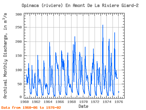
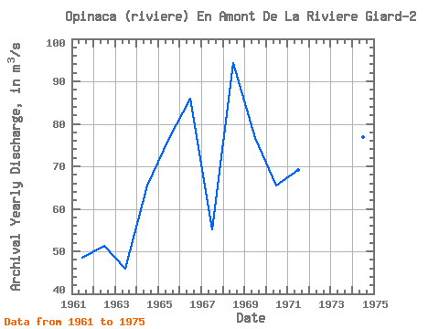
| Year | Jan | Feb | Mar | Apr | May | Jun | Jul | Aug | Sep | Oct | Nov | Dec | Annual | 1960 | 82.50 | 49.40 | 74.30 | 54.00 | 122.00 | 90.90 | 59.30 | 1961 | 24.10 | 16.40 | 14.20 | 21.70 | 116.00 | 53.20 | 44.10 | 33.80 | 37.60 | 68.90 | 88.60 | 63.70 | 48.52 | 1962 | 27.40 | 14.60 | 9.92 | 8.19 | 151.00 | 85.80 | 48.00 | 57.20 | 67.80 | 59.10 | 52.90 | 32.60 | 51.21 | 1963 | 16.70 | 12.00 | 10.70 | 12.60 | 132.00 | 102.00 | 49.80 | 43.60 | 32.80 | 51.80 | 40.70 | 46.30 | 45.92 | 1964 | 19.70 | 14.90 | 12.70 | 19.10 | 196.00 | 136.00 | 39.10 | 52.90 | 93.60 | 115.00 | 58.20 | 28.00 | 65.43 | 1965 | 14.20 | 9.87 | 8.04 | 7.30 | 161.00 | 154.00 | 128.00 | 121.00 | 104.00 | 118.00 | 66.60 | 28.80 | 76.73 | 1966 | 16.30 | 13.60 | 13.50 | 51.20 | 167.00 | 151.00 | 103.00 | 138.00 | 101.00 | 133.00 | 91.00 | 51.10 | 85.81 | 1967 | 22.80 | 15.80 | 12.20 | 11.10 | 143.00 | 160.00 | 53.00 | 77.70 | 40.30 | 38.60 | 49.50 | 39.00 | 55.25 | 1968 | 29.00 | 24.00 | 20.30 | 104.00 | 189.00 | 57.70 | 103.00 | 217.00 | 142.00 | 132.00 | 73.30 | 39.80 | 94.26 | 1969 | 27.00 | 19.50 | 13.00 | 11.50 | 124.00 | 162.00 | 144.00 | 48.80 | 81.60 | 145.00 | 88.50 | 54.20 | 76.59 | 1970 | 32.60 | 23.80 | 18.50 | 16.00 | 180.00 | 116.00 | 100.00 | 62.80 | 72.30 | 81.10 | 48.50 | 35.30 | 65.58 | 1971 | 23.20 | 15.40 | 10.30 | 9.39 | 88.60 | 50.30 | 74.70 | 124.00 | 103.00 | 174.00 | 102.00 | 55.40 | 69.19 | 1972 | 28.20 | 17.90 | 12.80 | 9.59 | 130.00 | 114.00 | 68.50 | 47.40 | 99.40 | 108.00 | 65.50 | 33.50 | 61.23 | 1973 | 20.80 | 15.70 | 13.40 | 26.80 | 258.00 | 77.10 | 76.70 | 32.60 | 85.60 | 114.00 | 78.00 | 40.30 | 69.92 | 1974 | 24.40 | 15.60 | 10.20 | 8.62 | 176.00 | 208.00 | 51.90 | 25.60 | 97.20 | 159.00 | 90.40 | 54.40 | 76.78 | 1975 | 28.10 | 16.20 | 10.80 | 10.60 | 231.00 | 113.00 | 75.00 | 97.50 | 73.30 | 70.60 | 120.00 | 52.70 | 74.90 | 1976 | 22.30 | 13.50 |
|---|
 Return to R-Arctic Net Home Page