|
|
|||||||||||||||||
| Point ID: 5109 | Downloads | Plots | Site Data | Code: 03CD002 |
|
|
|||||||||||||||||
| Download | |
|---|---|
| Site Descriptor Information | Site Time Series Data |
| Link to all available data | |
| View: | Time Series | All |
| Units: | m3/s |
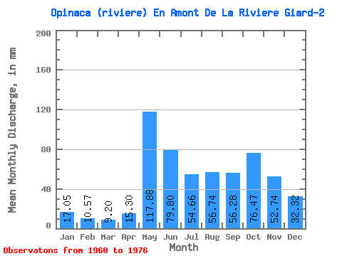
| Statistic | Jan | Feb | Mar | Apr | May | Jun | Jul | Aug | Sep | Oct | Nov | Dec | Annual |
|---|---|---|---|---|---|---|---|---|---|---|---|---|---|
| Mean | 17.05 | 10.67 | 9.20 | 15.30 | 117.86 | 79.80 | 54.66 | 56.74 | 56.28 | 76.45 | 52.74 | 32.32 | 578.50 |
| Standard Deviation | 3.71 | 2.47 | 2.32 | 17.75 | 32.22 | 31.81 | 22.95 | 36.58 | 20.47 | 28.85 | 15.49 | 8.25 | 117.48 |
| Min | 10.28 | 6.51 | 5.82 | 5.11 | 64.13 | 35.24 | 28.30 | 18.53 | 22.98 | 27.94 | 28.51 | 20.27 | 391.66 |
| Max | 23.59 | 15.83 | 14.69 | 72.86 | 186.74 | 145.71 | 104.22 | 157.06 | 99.48 | 125.94 | 84.06 | 46.10 | 804.00 |
| Coefficient of Variation | 0.22 | 0.23 | 0.25 | 1.16 | 0.27 | 0.40 | 0.42 | 0.65 | 0.36 | 0.38 | 0.29 | 0.26 | 0.20 |
 Return to R-Arctic Net Home Page