| PointID: | 6752 | Code: | 10220 | Latitude (decimal degrees): | 55.00 | Longitude (decimal degrees): | 83.33 | Drainage Area (km2): | 17300.00 | Source: | SHI | Hydrological Zone: | Ob | Name: | Inya (Nygnyaya) at Berezovka |
|---|
| Download | |
|---|---|
| Site Descriptor Information | Site Time Series Data |
| Link to all available data | |
| ID | Year | Jan | Feb | Mar | Apr | May | Jun | Jul | Aug | Sep | Oct | Nov | Dec |
|---|---|---|---|---|---|---|---|---|---|---|---|---|---|
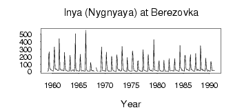
| 6752 | 1959 | 9.33 | 8.45 | 9.62 | 225.00 | 266.00 | 52.50 | 39.90 | 33.10 | 23.40 | 22.80 | 19.10 | 13.70 |
| 6752 | 1960 | 11.90 | 10.00 | 10.20 | 242.00 | 329.00 | 129.00 | 36.50 | 31.90 | 34.30 | 35.10 | 25.80 | 16.90 |
| 6752 | 1961 | 17.20 | 18.20 | 18.90 | 440.00 | 193.00 | 38.50 | 27.20 | 26.00 | 17.40 | 19.40 | 24.70 | 17.20 |
| 6752 | 1962 | 13.40 | 12.30 | 16.30 | 258.00 | 155.00 | 46.40 | 20.20 | 16.00 | 16.10 | 10.60 | 6.51 | 6.27 |
| 6752 | 1963 | 6.63 | 7.36 | 7.72 | 71.20 | 220.00 | 25.40 | 8.82 | 9.74 | 13.40 | 20.40 | 23.60 | 24.50 |
| 6752 | 1964 | 13.30 | 8.60 | 5.00 | 92.70 | 505.00 | 50.50 | 18.70 | 9.70 | 14.50 | 13.10 | 12.50 | 11.70 |
| 6752 | 1965 | 7.04 | 6.40 | 13.10 | 231.00 | 150.00 | 30.00 | 10.30 | 11.20 | 10.70 | 17.50 | 16.90 | 8.69 |
| 6752 | 1966 | 6.96 | 6.25 | 7.08 | 177.00 | 552.00 | 60.70 | 25.80 | 13.70 | 8.74 | 6.44 | 5.80 | 5.63 |
| 6752 | 1967 | 4.45 | 4.79 | 4.94 | 124.00 | 71.30 | 20.20 | 13.60 | 9.91 | 18.40 | 15.50 | 8.74 | 5.40 |
| 6752 | 1968 | 54.80 | 17.00 | 9.12 | 7.70 | 7.11 | |||||||
| 6752 | 1969 | 3.99 | 3.19 | 3.04 | 124.00 | 330.00 | 134.00 | 16.00 | 13.40 | 13.90 | 11.60 | 17.80 | 12.00 |
| 6752 | 1970 | 8.88 | 6.27 | 7.46 | 262.00 | 93.90 | 42.00 | 18.00 | 13.10 | 5.59 | 11.10 | 8.06 | 5.14 |
| 6752 | 1971 | 5.05 | 5.67 | 5.15 | 207.00 | 155.00 | 40.30 | 24.10 | 15.00 | 11.80 | 10.00 | 10.00 | 7.86 |
| 6752 | 1972 | 2.17 | 2.65 | 3.82 | 225.00 | 160.00 | 42.60 | 32.10 | 18.20 | 20.10 | 28.80 | 14.10 | 9.92 |
| 6752 | 1973 | 13.20 | 12.00 | 11.40 | 336.00 | 243.00 | 52.00 | 25.00 | 19.40 | 13.00 | 11.80 | 9.49 | 5.47 |
| 6752 | 1974 | 5.80 | 3.70 | 2.81 | 189.00 | 85.10 | 26.60 | 18.40 | 12.90 | 11.70 | 11.50 | 7.06 | 4.69 |
| 6752 | 1975 | 4.48 | 5.21 | 10.50 | 278.00 | 217.00 | 95.40 | 17.40 | 13.30 | 11.60 | 14.40 | 7.78 | 3.66 |
| 6752 | 1976 | 5.13 | 3.49 | 5.59 | 138.00 | 146.00 | 23.40 | 21.70 | 17.40 | 12.60 | 13.20 | 8.33 | 8.45 |
| 6752 | 1977 | 6.49 | 3.93 | 7.91 | 293.00 | 200.00 | 26.80 | 15.20 | 16.20 | 15.20 | 11.00 | 9.70 | 7.29 |
| 6752 | 1978 | 5.84 | 3.33 | 5.89 | 230.00 | 110.00 | 41.60 | 24.80 | 27.80 | 15.40 | 14.70 | 22.90 | 10.90 |
| 6752 | 1979 | 7.74 | 6.24 | 7.65 | 133.00 | 427.00 | 106.00 | 27.50 | 16.70 | 16.70 | 15.20 | 17.40 | 12.00 |
| 6752 | 1980 | 9.12 | 7.34 | 7.84 | 110.00 | 145.00 | 39.50 | 13.90 | 15.20 | 7.70 | 9.07 | 9.82 | 7.64 |
| 6752 | 1981 | 5.13 | 4.37 | 8.68 | 151.00 | 71.30 | 25.10 | 5.45 | 8.57 | 10.50 | 9.20 | 7.64 | 4.67 |
| 6752 | 1982 | 4.56 | 3.51 | 3.77 | 177.00 | 64.90 | 17.10 | 12.20 | 12.60 | 15.60 | 16.00 | 15.60 | 11.70 |
| 6752 | 1983 | 12.80 | 12.70 | 7.78 | 99.90 | 174.00 | 37.30 | 21.40 | 21.70 | 12.90 | 13.10 | 13.70 | 11.60 |
| 6752 | 1984 | 7.65 | 5.45 | 5.09 | 75.40 | 350.00 | 55.30 | 46.40 | 40.70 | 17.10 | 25.00 | 19.10 | 12.60 |
| 6752 | 1985 | 11.80 | 12.70 | 7.16 | 213.00 | 217.00 | 74.30 | 40.20 | 26.10 | 25.60 | 32.10 | 28.40 | 19.00 |
| 6752 | 1986 | 16.50 | 10.60 | 12.40 | 169.00 | 226.00 | 56.70 | 24.20 | 25.70 | 22.30 | 21.10 | 14.00 | 10.10 |
| 6752 | 1987 | 8.27 | 7.67 | 10.40 | 109.00 | 241.00 | 48.60 | 30.00 | 16.00 | 20.10 | 35.20 | 22.60 | 14.90 |
| 6752 | 1988 | 14.30 | 13.30 | 12.10 | 344.00 | 225.00 | 40.20 | 24.80 | 33.70 | 16.90 | 19.60 | 23.20 | 13.40 |
| 6752 | 1989 | 10.90 | 9.80 | 14.70 | 182.00 | 99.00 | 40.70 | 18.90 | 10.30 | 8.25 | 18.10 | 20.60 | 8.87 |
| 6752 | 1990 | 8.34 | 8.23 | 12.80 | 137.00 | 101.00 | 23.70 | 14.70 | 17.80 | 18.90 | 20.20 | 14.70 | 12.80 |
| Other Close Sites | ||||||
|---|---|---|---|---|---|---|
| PointID | Latitude | Longitude | Drainage Area | Source | Name | |
| 6660 | 54.80 | 82.95 | 232000.00 | SHI | Ob at HPS Novosibirskaya | |
| 6661 | 55.00 | 82.95 | 252000.00 | SHI | Ob at Novosibirsk | |
 Return to R-Arctic Net Home Page