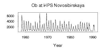
| PointID: | 6660 | Code: | 10011 | Latitude (decimal degrees): | 54.80 | Longitude (decimal degrees): | 82.95 | Drainage Area (km2): | 232000.00 | Source: | SHI | Hydrological Zone: | Ob | Name: | Ob at HPS Novosibirskaya |
|---|
| Download | |
|---|---|
| Site Descriptor Information | Site Time Series Data |
| Link to all available data | |
| ID | Year | Jan | Feb | Mar | Apr | May | Jun | Jul | Aug | Sep | Oct | Nov | Dec |
|---|---|---|---|---|---|---|---|---|---|---|---|---|---|
| 6660 | 1958 | 629.00 | 463.00 | 428.00 | 1110.00 | 6330.00 | 5610.00 | 5000.00 | 3750.00 | 1730.00 | 1390.00 | 894.00 | 489.00 |
| 6660 | 1959 | 451.00 | 454.00 | 663.00 | 1410.00 | 4390.00 | 3720.00 | 2700.00 | 1670.00 | 1260.00 | 825.00 | 560.00 | 523.00 |
| 6660 | 1960 | 813.00 | 706.00 | 723.00 | 1010.00 | 4090.00 | 3720.00 | 3830.00 | 2610.00 | 2060.00 | 1300.00 | 664.00 | 603.00 |
| 6660 | 1961 | 792.00 | 983.00 | 950.00 | 3020.00 | 4140.00 | 3820.00 | 3150.00 | 2530.00 | 2120.00 | 1610.00 | 1080.00 | 696.00 |
| 6660 | 1962 | 1120.00 | 982.00 | 934.00 | 2150.00 | 3480.00 | 3260.00 | 1440.00 | 1250.00 | 955.00 | 824.00 | 705.00 | 619.00 |
| 6660 | 1963 | 776.00 | 618.00 | 778.00 | 1290.00 | 2510.00 | 2200.00 | 1790.00 | 1350.00 | 1080.00 | 1010.00 | 1060.00 | 659.00 |
| 6660 | 1964 | 780.00 | 833.00 | 578.00 | 905.00 | 3940.00 | 3330.00 | 2430.00 | 1500.00 | 1240.00 | 950.00 | 778.00 | 510.00 |
| 6660 | 1965 | 624.00 | 603.00 | 685.00 | 1850.00 | 3550.00 | 2350.00 | 1620.00 | 1180.00 | 1390.00 | 1320.00 | 786.00 | 691.00 |
| 6660 | 1966 | 853.00 | 734.00 | 670.00 | 1670.00 | 6920.00 | 5610.00 | 4620.00 | 1960.00 | 1270.00 | 1090.00 | 604.00 | 506.00 |
| 6660 | 1967 | 526.00 | 518.00 | 651.00 | 1590.00 | 1870.00 | 1910.00 | 1940.00 | 2970.00 | 1910.00 | 1340.00 | 840.00 | 506.00 |
| 6660 | 1968 | 520.00 | 503.00 | 682.00 | 2110.00 | 3240.00 | 2860.00 | 1430.00 | 1200.00 | 930.00 | 792.00 | 570.00 | 436.00 |
| 6660 | 1969 | 462.00 | 585.00 | 718.00 | 1200.00 | 6750.00 | 7000.00 | 3680.00 | 1970.00 | 1760.00 | 1930.00 | 1210.00 | 688.00 |
| 6660 | 1970 | 683.00 | 664.00 | 874.00 | 3080.00 | 3100.00 | 4400.00 | 2890.00 | 1970.00 | 1510.00 | 1610.00 | 1170.00 | 539.00 |
| 6660 | 1971 | 542.00 | 652.00 | 969.00 | 2520.00 | 4520.00 | 3920.00 | 3170.00 | 1610.00 | 1270.00 | 1000.00 | 862.00 | 477.00 |
| 6660 | 1972 | 438.00 | 446.00 | 592.00 | 2450.00 | 3430.00 | 3520.00 | 2530.00 | 1720.00 | 1340.00 | 1300.00 | 881.00 | 484.00 |
| 6660 | 1973 | 824.00 | 851.00 | 766.00 | 2790.00 | 4620.00 | 4590.00 | 4210.00 | 2060.00 | 1410.00 | 1320.00 | 1010.00 | 507.00 |
| 6660 | 1974 | 505.00 | 596.00 | 575.00 | 1820.00 | 2560.00 | 2000.00 | 1430.00 | 1170.00 | 914.00 | 1010.00 | 782.00 | 520.00 |
| 6660 | 1975 | 562.00 | 532.00 | 629.00 | 2480.00 | 2560.00 | 4260.00 | 3050.00 | 1410.00 | 1250.00 | 1180.00 | 683.00 | 456.00 |
| 6660 | 1976 | 487.00 | 474.00 | 522.00 | 1020.00 | 3100.00 | 3010.00 | 2000.00 | 2240.00 | 1340.00 | 1430.00 | 777.00 | 555.00 |
| 6660 | 1977 | 753.00 | 770.00 | 749.00 | 2500.00 | 4200.00 | 3510.00 | 1980.00 | 1930.00 | 1580.00 | 1390.00 | 1230.00 | 671.00 |
| 6660 | 1978 | 605.00 | 686.00 | 711.00 | 2680.00 | 3060.00 | 2520.00 | 1900.00 | 1850.00 | 1350.00 | 1090.00 | 950.00 | 457.00 |
| 6660 | 1979 | 454.00 | 512.00 | 542.00 | 1110.00 | 3980.00 | 4010.00 | 2280.00 | 1430.00 | 1480.00 | 1310.00 | 1240.00 | 915.00 |
| 6660 | 1980 | 673.00 | 564.00 | 682.00 | 1230.00 | 2230.00 | 3110.00 | 2390.00 | 1540.00 | 1340.00 | 1170.00 | 1010.00 | 529.00 |
| 6660 | 1981 | 568.00 | 581.00 | 666.00 | 1440.00 | 2160.00 | 2190.00 | 1330.00 | 1310.00 | 1200.00 | 1160.00 | 964.00 | 555.00 |
| 6660 | 1982 | 613.00 | 581.00 | 520.00 | 1150.00 | 2290.00 | 2510.00 | 1360.00 | 1400.00 | 1130.00 | 963.00 | 993.00 | 504.00 |
| 6660 | 1983 | 542.00 | 568.00 | 798.00 | 1410.00 | 2260.00 | 3010.00 | 2450.00 | 1870.00 | 1250.00 | 1460.00 | 1050.00 | 653.00 |
| 6660 | 1984 | 597.00 | 597.00 | 685.00 | 1140.00 | 2810.00 | 3730.00 | 3670.00 | 3950.00 | 1510.00 | 1250.00 | 904.00 | 778.00 |
| 6660 | 1985 | 527.00 | 673.00 | 778.00 | 2060.00 | 2850.00 | 3580.00 | 3320.00 | 2020.00 | 1570.00 | 1230.00 | 952.00 | 536.00 |
| 6660 | 1986 | 739.00 | 866.00 | 730.00 | 1810.00 | 3520.00 | 2700.00 | 2010.00 | 1530.00 | 1410.00 | 1190.00 | 797.00 | 494.00 |
| 6660 | 1987 | 450.00 | 485.00 | 800.00 | 1270.00 | 3180.00 | 3670.00 | 2790.00 | 1420.00 | 1220.00 | 2000.00 | 899.00 | 579.00 |
| 6660 | 1988 | 645.00 | 845.00 | 817.00 | 2160.00 | 3520.00 | 2960.00 | 2410.00 | 2800.00 | 1500.00 | 1240.00 | 959.00 | 638.00 |
| 6660 | 1990 | 553.00 | 548.00 | 822.00 | 1640.00 | 2650.00 | 2750.00 | 2130.00 | 2750.00 | 2050.00 | 1320.00 | 800.00 | 522.00 |
| Other Close Sites | ||||||
|---|---|---|---|---|---|---|
| PointID | Latitude | Longitude | Drainage Area | Source | Name | |
| 6661 | 55.00 | 82.95 | 252000.00 | SHI | Ob at Novosibirsk | |
| 6752 | 55.00 | 83.33 | 17300.00 | SHI | Inya (Nygnyaya) at Berezovka | |
 Return to R-Arctic Net Home Page