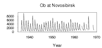
| PointID: | 6661 | Code: | 10014 | Latitude (decimal degrees): | 55.00 | Longitude (decimal degrees): | 82.95 | Drainage Area (km2): | 252000.00 | Source: | SHI | Hydrological Zone: | Ob | Name: | Ob at Novosibirsk |
|---|
| Download | |
|---|---|
| Site Descriptor Information | Site Time Series Data |
| Link to all available data | |
| ID | Year | Jan | Feb | Mar | Apr | May | Jun | Jul | Aug | Sep | Oct | Nov | Dec |
|---|---|---|---|---|---|---|---|---|---|---|---|---|---|
| 6661 | 1936 | 335.00 | 299.00 | 263.00 | 937.00 | 5170.00 | 5900.00 | 5110.00 | 2530.00 | 2080.00 | 1260.00 | 730.00 | 573.00 |
| 6661 | 1937 | 528.00 | 426.00 | 381.00 | 890.00 | 9480.00 | 6240.00 | 3810.00 | 2340.00 | 1500.00 | 1480.00 | 1080.00 | 549.00 |
| 6661 | 1938 | 462.00 | 415.00 | 354.00 | 3980.00 | 5490.00 | 5660.00 | 4710.00 | 3370.00 | 2380.00 | 1960.00 | 1280.00 | 706.00 |
| 6661 | 1939 | 614.00 | 434.00 | 425.00 | 2930.00 | 5880.00 | 3430.00 | 3200.00 | 1980.00 | 1150.00 | 992.00 | 452.00 | 436.00 |
| 6661 | 1940 | 414.00 | 284.00 | 323.00 | 3020.00 | 4240.00 | 3370.00 | 2310.00 | 1690.00 | 1540.00 | 1000.00 | 579.00 | 635.00 |
| 6661 | 1941 | 496.00 | 430.00 | 412.00 | 1820.00 | 8210.00 | 5810.00 | 3560.00 | 2320.00 | 1780.00 | 1570.00 | 785.00 | 554.00 |
| 6661 | 1942 | 536.00 | 434.00 | 398.00 | 1500.00 | 6150.00 | 4080.00 | 3720.00 | 2810.00 | 1430.00 | 1760.00 | 1080.00 | 689.00 |
| 6661 | 1943 | 458.00 | 396.00 | 372.00 | 2380.00 | 4130.00 | 4020.00 | 2520.00 | 1540.00 | 1080.00 | 776.00 | 482.00 | 392.00 |
| 6661 | 1944 | 329.00 | 259.00 | 309.00 | 2580.00 | 3300.00 | 3550.00 | 2950.00 | 2120.00 | 1410.00 | 1150.00 | 636.00 | 340.00 |
| 6661 | 1945 | 322.00 | 287.00 | 213.00 | 2330.00 | 3940.00 | 2090.00 | 1370.00 | 1550.00 | 878.00 | 686.00 | 444.00 | 390.00 |
| 6661 | 1946 | 342.00 | 328.00 | 314.00 | 2480.00 | 3740.00 | 4810.00 | 3190.00 | 2470.00 | 3000.00 | 2660.00 | 1500.00 | 768.00 |
| 6661 | 1947 | 740.00 | 580.00 | 520.00 | 5100.00 | 3780.00 | 4310.00 | 3780.00 | 2860.00 | 2100.00 | 1360.00 | 723.00 | 650.00 |
| 6661 | 1948 | 558.00 | 442.00 | 423.00 | 4000.00 | 5380.00 | 4060.00 | 3480.00 | 2040.00 | 1400.00 | 1390.00 | 700.00 | 591.00 |
| 6661 | 1949 | 506.00 | 459.00 | 369.00 | 2930.00 | 5720.00 | 4150.00 | 3190.00 | 1820.00 | 1430.00 | 1170.00 | 694.00 | 493.00 |
| 6661 | 1950 | 459.00 | 414.00 | 324.00 | 1340.00 | 7010.00 | 6070.00 | 2450.00 | 1960.00 | 1630.00 | 1130.00 | 541.00 | 474.00 |
| 6661 | 1951 | 388.00 | 346.00 | 298.00 | 2510.00 | 4800.00 | 2500.00 | 1670.00 | 1280.00 | 869.00 | 770.00 | 512.00 | 460.00 |
| 6661 | 1952 | 378.00 | 319.00 | 284.00 | 905.00 | 5450.00 | 4870.00 | 3620.00 | 2580.00 | 1410.00 | 1010.00 | 528.00 | 462.00 |
| 6661 | 1953 | 426.00 | 374.00 | 393.00 | 3310.00 | 4120.00 | 3340.00 | 1730.00 | 1380.00 | 965.00 | 824.00 | 478.00 | 413.00 |
| 6661 | 1954 | 343.00 | 288.00 | 271.00 | 594.00 | 5340.00 | 5150.00 | 5490.00 | 2440.00 | 2050.00 | 1290.00 | 963.00 | 558.00 |
| 6661 | 1955 | 389.00 | 334.00 | 314.00 | 2800.00 | 4950.00 | 2980.00 | 1580.00 | 1270.00 | 1170.00 | 1340.00 | 502.00 | 410.00 |
| 6661 | 1956 | 267.00 | 260.00 | 236.00 | 2610.00 | 3330.00 | 4080.00 | 3510.00 | 1910.00 | 2140.00 | 1390.00 | 966.00 | 469.00 |
| 6661 | 1957 | 366.00 | 318.00 | 319.00 | 2630.00 | 4750.00 | 4020.00 | 3500.00 | 2320.00 | 1870.00 | 1510.00 | 1510.00 | 593.00 |
| 6661 | 1958 | 691.00 | 476.00 | 448.00 | 1500.00 | 6430.00 | 5970.00 | 5340.00 | 3970.00 | 2190.00 | 1590.00 | 1220.00 | 743.00 |
| 6661 | 1959 | 468.00 | 464.00 | 651.00 | 1550.00 | 4640.00 | 4030.00 | 3080.00 | 2080.00 | 1620.00 | 1090.00 | 723.00 | 546.00 |
| 6661 | 1960 | 944.00 | 893.00 | 839.00 | 1370.00 | 4710.00 | 4420.00 | 4480.00 | 2640.00 | 2090.00 | 1340.00 | 704.00 | 645.00 |
| 6661 | 1961 | 901.00 | 1220.00 | 1220.00 | 3670.00 | 4680.00 | 4100.00 | 3430.00 | 2760.00 | 2360.00 | 1810.00 | 1370.00 | 753.00 |
| 6661 | 1962 | 1380.00 | 1300.00 | 1310.00 | 2840.00 | 3880.00 | 3650.00 | 1730.00 | 1470.00 | 1080.00 | 877.00 | 782.00 | 623.00 |
| 6661 | 1963 | 2980.00 | 2450.00 | 2000.00 | 1500.00 | 1190.00 | 1140.00 | ||||||
| 6661 | 1964 | 814.00 | 1070.00 | 641.00 | 1300.00 | 4720.00 | 3590.00 | 2750.00 | 1730.00 | 1380.00 | 988.00 | 911.00 | 674.00 |
| 6661 | 1965 | 3830.00 | 2570.00 | 1810.00 | 1290.00 | 1510.00 | 1440.00 | ||||||
| 6661 | 1966 | 894.00 | 835.00 | 799.00 | 1880.00 | 8000.00 | 5950.00 | 5110.00 | 2220.00 | 1390.00 | 1160.00 | ||
| 6661 | 1968 | 3400.00 | 3040.00 | 1510.00 | 1220.00 | 919.00 | 812.00 |
| Other Close Sites | ||||||
|---|---|---|---|---|---|---|
| PointID | Latitude | Longitude | Drainage Area | Source | Name | |
| 6660 | 54.80 | 82.95 | 232000.00 | SHI | Ob at HPS Novosibirskaya | |
| 6752 | 55.00 | 83.33 | 17300.00 | SHI | Inya (Nygnyaya) at Berezovka | |
 Return to R-Arctic Net Home Page