| PointID: | 5116 | Code: | 03DC001 | Latitude (decimal degrees): | 53.68 | Longitude (decimal degrees): | -76.79 | Drainage Area (km2): | 74100.00 | Source: | Hydat | Hydrological Zone: | South and East Hudson Bay | Name: | GRANDE RIVIERE (LA) EN AVAL DE LA RIVIERE SAKAMI |
|---|
| Download | |
|---|---|
| Site Descriptor Information | Site Time Series Data |
| Link to all available data | |
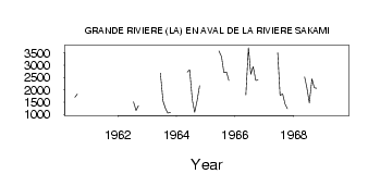
| ID | Year | Jan | Feb | Mar | Apr | May | Jun | Jul | Aug | Sep | Oct | Nov | Dec |
|---|---|---|---|---|---|---|---|---|---|---|---|---|---|
| 5116 | 1960 | 1700.00 | 1830.00 | ||||||||||
| 5116 | 1962 | 1510.00 | 1160.00 | 1350.00 | |||||||||
| 5116 | 1963 | 2680.00 | 1540.00 | 1260.00 | 1050.00 | 1080.00 | |||||||
| 5116 | 1964 | 2720.00 | 2810.00 | 1590.00 | 1090.00 | 1530.00 | 2170.00 | ||||||
| 5116 | 1965 | 3580.00 | 3350.00 | 2700.00 | 2720.00 | 2380.00 | |||||||
| 5116 | 1966 | 1800.00 | 3710.00 | 2640.00 | 2940.00 | 2380.00 | 2400.00 | ||||||
| 5116 | 1967 | 3510.00 | 1780.00 | 1830.00 | 1420.00 | 1230.00 | |||||||
| 5116 | 1968 | 2520.00 | 2060.00 | 1470.00 | 2440.00 | 2080.00 | 2060.00 | ||||||
| 5116 | 1969 | 2910.00 |
| Other Close Sites | ||||||
|---|---|---|---|---|---|---|
| PointID | Latitude | Longitude | Drainage Area | Source | Name | |
| 5113 | 53.75 | -76.98 | 18600.00 | Hydat | KANAAUPSCOW (RIVIERE) EN AMONT DU RUISSEAU POUTRE | |
| 5114 | 53.75 | -76.97 | 18600.00 | Hydat | KANAAUPSCOW (RIVIERE) EN AMONT DU RUISSEAU POUTRE-2 | |
| 5126 | 53.65 | -76.64 | 10900.00 | Hydat | SAKAMI (RIVIERE) PRES DE LA GRANDE RIVIERE | |
 Return to R-Arctic Net Home Page