| PointID: | 5113 | Code: | 03DB002 | Latitude (decimal degrees): | 53.75 | Longitude (decimal degrees): | -76.98 | Drainage Area (km2): | 18600.00 | Source: | Hydat | Hydrological Zone: | South and East Hudson Bay | Name: | KANAAUPSCOW (RIVIERE) EN AMONT DU RUISSEAU POUTRE |
|---|
| Download | |
|---|---|
| Site Descriptor Information | Site Time Series Data |
| Link to all available data | |
| ID | Year | Jan | Feb | Mar | Apr | May | Jun | Jul | Aug | Sep | Oct | Nov | Dec |
|---|---|---|---|---|---|---|---|---|---|---|---|---|---|
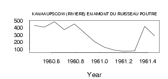
| 5113 | 1960 | 434.00 | 409.00 | 485.00 | 374.00 | 453.00 | 331.00 | 207.00 | |||||
| 5113 | 1961 | 127.00 | 88.00 | 71.00 | 80.00 | 420.00 | 288.00 |
| Other Close Sites | ||||||
|---|---|---|---|---|---|---|
| PointID | Latitude | Longitude | Drainage Area | Source | Name | |
| 5114 | 53.75 | -76.97 | 18600.00 | Hydat | KANAAUPSCOW (RIVIERE) EN AMONT DU RUISSEAU POUTRE-2 | |
| 5116 | 53.68 | -76.79 | 74100.00 | Hydat | GRANDE RIVIERE (LA) EN AVAL DE LA RIVIERE SAKAMI | |
| 5126 | 53.65 | -76.64 | 10900.00 | Hydat | SAKAMI (RIVIERE) PRES DE LA GRANDE RIVIERE | |
 Return to R-Arctic Net Home Page