| PointID: | 5114 | Code: | 03DB003 | Latitude (decimal degrees): | 53.75 | Longitude (decimal degrees): | -76.97 | Drainage Area (km2): | 18600.00 | Source: | Hydat | Hydrological Zone: | South and East Hudson Bay | Name: | KANAAUPSCOW (RIVIERE) EN AMONT DU RUISSEAU POUTRE-2 |
|---|
| Download | |
|---|---|
| Site Descriptor Information | Site Time Series Data |
| Link to all available data | |
| ID | Year | Jan | Feb | Mar | Apr | May | Jun | Jul | Aug | Sep | Oct | Nov | Dec |
|---|---|---|---|---|---|---|---|---|---|---|---|---|---|
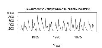
| 5114 | 1961 | 146.00 | 188.00 | 342.00 | 318.00 | 237.00 | |||||||
| 5114 | 1962 | 131.00 | 78.00 | 61.00 | 57.00 | 476.00 | 546.00 | 275.00 | 180.00 | 282.00 | 325.00 | 276.00 | 203.00 |
| 5114 | 1963 | 127.00 | 89.00 | 73.00 | 79.00 | 650.00 | 524.00 | 304.00 | 304.00 | 230.00 | 219.00 | 220.00 | 223.00 |
| 5114 | 1964 | 130.00 | 88.00 | 73.00 | 81.00 | 671.00 | 483.00 | 238.00 | 222.00 | 379.00 | 488.00 | 355.00 | 233.00 |
| 5114 | 1965 | 143.00 | 96.00 | 68.00 | 55.00 | 203.00 | 901.00 | 729.00 | 447.00 | 532.00 | 431.00 | 290.00 | 197.00 |
| 5114 | 1966 | 112.00 | 72.00 | 58.00 | 97.00 | 481.00 | 748.00 | 534.00 | 535.00 | 409.00 | 484.00 | 297.00 | 229.00 |
| 5114 | 1967 | 145.00 | 89.00 | 70.00 | 67.00 | 450.00 | 736.00 | 330.00 | 275.00 | 223.00 | 288.00 | 317.00 | 187.00 |
| 5114 | 1968 | 114.00 | 86.00 | 68.00 | 54.00 | 442.00 | 337.00 | 273.00 | 443.00 | 387.00 | 542.00 | 376.00 | 188.00 |
| 5114 | 1969 | 111.00 | 89.00 | 81.00 | 73.00 | 333.00 | 509.00 | 403.00 | 296.00 | ||||
| 5114 | 1970 | 184.00 | 126.00 | 85.00 | 68.00 | 293.00 | 677.00 | 449.00 | 355.00 | 324.00 | 337.00 | 235.00 | 149.00 |
| 5114 | 1971 | 88.00 | 68.00 | 60.00 | 87.00 | 289.00 | 245.00 | 436.00 | 561.00 | 417.00 | 460.00 | 304.00 | 155.00 |
| 5114 | 1972 | 100.00 | 81.00 | 68.00 | 55.00 | 290.00 | 587.00 | 425.00 | 517.00 | 501.00 | 451.00 | 248.00 | 146.00 |
| 5114 | 1973 | 112.00 | 97.00 | 86.00 | 89.00 | 984.00 | 523.00 | 495.00 | 216.00 | 284.00 | 446.00 | 433.00 | 258.00 |
| 5114 | 1974 | 160.00 | 120.00 | 92.00 | 71.00 | 405.00 | 674.00 | 262.00 | 163.00 | 293.00 | 390.00 | 303.00 | 188.00 |
| 5114 | 1975 | 118.00 | 87.00 | 68.00 | 57.00 | 513.00 | 651.00 | 544.00 | 717.00 | 349.00 | 296.00 | 378.00 | 226.00 |
| 5114 | 1976 | 134.00 | 89.00 | 69.00 | 66.00 | 448.00 | 532.00 | 340.00 | 307.00 | 217.00 | 241.00 | 193.00 | 139.00 |
| 5114 | 1977 | 99.00 | 81.00 | 72.00 | 86.00 | 572.00 | 590.00 | 594.00 | 435.00 | 382.00 | 274.00 | 350.00 | 253.00 |
| 5114 | 1978 | 131.00 | 83.00 | 81.00 | 54.00 | 404.00 | 434.00 | 292.00 | 375.00 | 387.00 |
| Other Close Sites | ||||||
|---|---|---|---|---|---|---|
| PointID | Latitude | Longitude | Drainage Area | Source | Name | |
| 5113 | 53.75 | -76.98 | 18600.00 | Hydat | KANAAUPSCOW (RIVIERE) EN AMONT DU RUISSEAU POUTRE | |
| 5116 | 53.68 | -76.79 | 74100.00 | Hydat | GRANDE RIVIERE (LA) EN AVAL DE LA RIVIERE SAKAMI | |
| 5126 | 53.65 | -76.64 | 10900.00 | Hydat | SAKAMI (RIVIERE) PRES DE LA GRANDE RIVIERE | |
 Return to R-Arctic Net Home Page