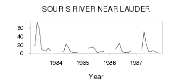
| PointID: | 2951 | Code: | 05NG025 | Latitude (decimal degrees): | 49.40 | Longitude (decimal degrees): | -100.76 | Drainage Area (km2): | 51700.00 | Source: | Hydat | Hydrological Zone: | Nelson | Name: | SOURIS RIVER NEAR LAUDER |
|---|
| Download | |
|---|---|
| Site Descriptor Information | Site Time Series Data |
| Link to all available data | |
| ID | Year | Jan | Feb | Mar | Apr | May | Jun | Jul | Aug | Sep | Oct | Nov | Dec |
|---|---|---|---|---|---|---|---|---|---|---|---|---|---|
| 2951 | 1983 | 17.00 | 73.00 | 57.00 | 9.33 | 6.34 | 4.70 | 12.20 | 5.72 | ||||
| 2951 | 1984 | 3.00 | 4.00 | 22.30 | 14.60 | 3.34 | 2.23 | 1.41 | 2.12 | ||||
| 2951 | 1985 | 12.00 | 13.00 | 14.90 | 8.98 | 1.22 | 2.87 | 3.69 | 4.70 | ||||
| 2951 | 1986 | 9.00 | 15.00 | 23.40 | 5.68 | 2.01 | 2.09 | 1.40 | 5.20 | ||||
| 2951 | 1987 | 8.00 | 52.00 | 20.30 | 4.68 | 3.72 | 6.18 | 3.14 | 1.90 |
| Other Close Sites | ||||||
|---|---|---|---|---|---|---|
| PointID | Latitude | Longitude | Drainage Area | Source | Name | |
| 2927 | 49.26 | -100.97 | 49100.00 | Hydat | SOURIS RIVER AT MELITA | |
| 2932 | 49.17 | -101.03 | 48100.00 | Hydat | SOURIS RIVER NEAR MELITA | |
| 2934 | 48.99 | -100.95 | 43700.00 | Hydat | SOURIS RIVER NEAR WESTHOPE | |
| 2937 | 49.09 | -100.95 | 44000.00 | Hydat | SOURIS RIVER NEAR COULTER | |
 Return to R-Arctic Net Home Page