| PointID: | 2937 | Code: | 05NF016 | Latitude (decimal degrees): | 49.09 | Longitude (decimal degrees): | -100.95 | Drainage Area (km2): | 44000.00 | Source: | Hydat | Hydrological Zone: | Nelson | Name: | SOURIS RIVER NEAR COULTER |
|---|
| Download | |
|---|---|
| Site Descriptor Information | Site Time Series Data |
| Link to all available data | |
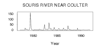
| ID | Year | Jan | Feb | Mar | Apr | May | Jun | Jul | Aug | Sep | Oct | Nov | Dec |
|---|---|---|---|---|---|---|---|---|---|---|---|---|---|
| 2937 | 1977 | 0.00 | 0.00 | 0.11 | 0.46 | 0.41 | 0.48 | 0.50 | 0.45 | 0.00 | 0.00 | ||
| 2937 | 1978 | 0.00 | 0.00 | 0.00 | 17.00 | 7.71 | 1.63 | 6.14 | 7.08 | 4.47 | 0.60 | 0.00 | 0.00 |
| 2937 | 1979 | 0.00 | 1.00 | 4.00 | 23.00 | 161.00 | 104.00 | 28.50 | 5.40 | 0.85 | 0.67 | 0.00 | 0.00 |
| 2937 | 1980 | 0.00 | 1.00 | 0.00 | 3.00 | 4.38 | 1.07 | 0.98 | 1.12 | 1.30 | 3.57 | 2.00 | 2.00 |
| 2937 | 1981 | 1.00 | 0.00 | 4.00 | 7.00 | 3.73 | 4.67 | 1.82 | 1.21 | 1.11 | 1.00 | 0.00 | 0.00 |
| 2937 | 1982 | 0.00 | 0.00 | 0.00 | 27.00 | 50.50 | 17.80 | 3.30 | 3.68 | 4.79 | 6.94 | 8.00 | 1.00 |
| 2937 | 1983 | 1.00 | 3.00 | 20.00 | 67.00 | 50.10 | 6.44 | 6.10 | 5.10 | 13.40 | 6.54 | 3.00 | 0.00 |
| 2937 | 1984 | 0.00 | 0.00 | 4.00 | 3.00 | 24.20 | 13.20 | 4.04 | 2.40 | 1.43 | 1.52 | 2.00 | 0.00 |
| 2937 | 1985 | 0.00 | 0.00 | 6.00 | 8.00 | 14.20 | 7.95 | 1.60 | 0.93 | 0.74 | 2.63 | 1.00 | 1.00 |
| 2937 | 1986 | 1.00 | 0.00 | 1.00 | 13.00 | 17.30 | 4.52 | 1.16 | 1.18 | 1.75 | 5.58 | 1.00 | 0.00 |
| 2937 | 1987 | 0.00 | 0.00 | 7.00 | 39.00 | 16.50 | 5.74 | 3.57 | 6.62 | 2.73 | 1.78 | 2.00 | 0.00 |
| 2937 | 1988 | 0.00 | 0.00 | 0.00 | 0.00 | 3.0e-03 | 0.73 | 0.85 | 0.85 | 0.81 | 0.70 | 0.00 | 0.00 |
| 2937 | 1989 | 0.00 | 0.00 | 0.00 | 16.00 | 1.70 | 0.68 | 1.08 | 0.67 | 0.67 | 0.76 | 0.00 | 0.00 |
| 2937 | 1990 | 0.00 | 0.00 | 0.00 | 0.00 | 0.06 | 0.62 | 0.66 | 0.62 | 0.20 | 0.44 | 0.00 | 0.00 |
| 2937 | 1991 | 0.00 | 0.00 | 0.00 | 0.00 | 1.0e-03 | 0.41 | 0.53 | 0.74 | 0.71 | 0.74 | 0.00 | 0.00 |
| Other Close Sites | ||||||
|---|---|---|---|---|---|---|
| PointID | Latitude | Longitude | Drainage Area | Source | Name | |
| 2927 | 49.26 | -100.97 | 49100.00 | Hydat | SOURIS RIVER AT MELITA | |
| 2932 | 49.17 | -101.03 | 48100.00 | Hydat | SOURIS RIVER NEAR MELITA | |
| 2934 | 48.99 | -100.95 | 43700.00 | Hydat | SOURIS RIVER NEAR WESTHOPE | |
| 2951 | 49.40 | -100.76 | 51700.00 | Hydat | SOURIS RIVER NEAR LAUDER | |
 Return to R-Arctic Net Home Page