| PointID: | 2927 | Code: | 05NF001 | Latitude (decimal degrees): | 49.26 | Longitude (decimal degrees): | -100.97 | Drainage Area (km2): | 49100.00 | Source: | Hydat | Hydrological Zone: | Nelson | Name: | SOURIS RIVER AT MELITA |
|---|
| Download | |
|---|---|
| Site Descriptor Information | Site Time Series Data |
| Link to all available data | |
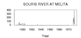
| ID | Year | Jan | Feb | Mar | Apr | May | Jun | Jul | Aug | Sep | Oct | Nov | Dec |
|---|---|---|---|---|---|---|---|---|---|---|---|---|---|
| 2927 | 1913 | 3.80 | 2.39 | 1.04 | 0.96 | 0.68 | |||||||
| 2927 | 1914 | 4.27 | 3.16 | 1.20 | 0.55 | ||||||||
| 2927 | 1915 | 0.00 | 0.00 | 0.00 | 0.00 | 2.03 | 1.10 | 0.78 | 0.27 | 0.63 | 0.67 | 0.00 | 0.00 |
| 2927 | 1916 | 0.00 | 0.00 | 0.00 | 44.00 | 64.20 | 37.50 | 9.60 | 5.19 | 1.66 | 1.54 | 0.00 | 0.00 |
| 2927 | 1917 | 0.00 | 0.00 | 0.00 | 20.00 | 26.70 | 10.40 | 2.56 | 0.48 | 0.27 | 0.22 | 0.00 | 0.00 |
| 2927 | 1918 | 0.00 | 0.00 | 1.00 | 10.00 | 4.79 | 2.05 | 0.48 | 0.49 | 0.34 | 0.35 | 0.00 | |
| 2927 | 1919 | 31.00 | 27.40 | 3.25 | 0.68 | 0.17 | 0.16 | 0.36 | |||||
| 2927 | 1920 | 24.00 | 43.80 | 20.40 | 3.82 | 1.58 | 0.81 | 0.61 | |||||
| 2927 | 1921 | 5.00 | 4.10 | 2.44 | 4.18 | 4.44 | 1.60 | 0.93 | 0.00 | ||||
| 2927 | 1922 | 0.00 | 35.00 | 28.90 | 10.10 | 3.39 | 1.76 | 0.89 | |||||
| 2927 | 1935 | 0.07 | |||||||||||
| 2927 | 1936 | 9.00 | 0.84 | 0.09 | 0.04 | 0.00 | 0.00 | ||||||
| 2927 | 1975 | 0.00 | 42.00 | 184.00 | 146.00 | 60.10 | |||||||
| 2927 | 1976 | 12.00 | 387.00 | 216.00 | 76.10 | 26.40 | 16.70 | 8.61 |
| Other Close Sites | ||||||
|---|---|---|---|---|---|---|
| PointID | Latitude | Longitude | Drainage Area | Source | Name | |
| 2932 | 49.17 | -101.03 | 48100.00 | Hydat | SOURIS RIVER NEAR MELITA | |
| 2934 | 48.99 | -100.95 | 43700.00 | Hydat | SOURIS RIVER NEAR WESTHOPE | |
| 2937 | 49.09 | -100.95 | 44000.00 | Hydat | SOURIS RIVER NEAR COULTER | |
| 2951 | 49.40 | -100.76 | 51700.00 | Hydat | SOURIS RIVER NEAR LAUDER | |
 Return to R-Arctic Net Home Page